|
|
Climate and Migration, Managed Retreat, and Data Best Practices Discussed by CIESIN Scientists
|
|
December 21, 2020
Associate director for Science Applications Alex de Sherbinin gave a talk December 18 on the intersection of climate change impacts and migration to the Uncommon Schools, a network of charter schools serving minority students in New York City. Earlier in the month, he also served on a panel, “In Crowding Climate Danger Zones, Seeking Paths to Managed Retreat,” held December 16 as part of the Sustain What? Webcast series. The panel, moderated by journalist Andrew Revkin, founding director of the Earth Institute's Initiative on Communication and Sustainability, also included colleagues Lisa Dale and Radley Horton, who with de Sherbinin are on the organizing committee for an upcoming 2021 conference on managed retreat. Senior digital archivist Robert Downs recently posted a blog entry for the World Data System (WDS) of the International Science Council (ISC) on data citation practices. The December 15 post summarizes an opinion piece published November 16 in EOS, with lead author Suresh Vannan and co-authors Walt Meier, Bruce Wilson, and Irina Gerasimov. The article argues that concerted efforts by the research community are needed to expand appropriate citation of data sets, in order to improve the provenance and reproducibility of research and thereby its credibility and value. In another WDS blog post, released December 4, de Sherbinin discusses current data practices in citizen science, based on an article co-authored with lead author Anne Bowser of the Wilson Center that was recently published in the journal Citizen Science: Theory and Practice. Improving data management practices in citizen science is critical to ensuring that these efforts produce useful data for scientific research or policy applications. The article was an output of a joint Task Group on the Validation, Curation, and Management of Citizen Science and Crowdsourced Data established by the ISC Committee on Data (CODATA) and the WDS, which de Sherbinin co-chaired. He is also the current chair of the WDS Scientific Committee and a co-chair of a new CODATA-WDS Task Group, “Citizen Science for the SDGs.”
See: “In Crowding Climate Danger Zones, Seeking Paths to Managed Retreat” (“Sustain What?” Webcast)
“Promoting Proper Data Citation Practices” (World Data System Blog)
“Current Data Practices in Citizen Science” (World Data System Blog)
|
|
Global Earth Science Community Connects Online for Annual Meeting
|
|
December 18, 2020
An online version of the annual American Geophysical Union (AGU) Fall Meeting brought together nearly 29,000 scientists and other experts for more than two weeks of online presentations, sessions, and exhibits December 1–17. CIESIN experts organized or co-chaired seven sessions and presented or co-authored twelve invited, oral, e-lightning, and poster papers, on a range of topics in multiple AGU tracks, including Global Change, Natural Hazards, Earth and Space Science Informatics, and Science and Society. Oral sessions included pre-recorded video talks of up to 15 minutes, combined with a one-hour live session with five-minute summaries and a moderated discussion. E-lightning sessions combined an online, interactive “iposter” with a one-hour live session with three-minute summaries and a discussion period. Posters consisted of an iposter made available for 24 hours within a designated visit period. This unique format enabled participation by scientists all over the world, albeit often at unusual hours of the day or night depending on time zones. Alex de Sherbinin, associate director for Science Applications, presented an e-lightning paper on the Global COVID-19 Viewer, a mapping tool for data related to the coronovirus pandemic developed by the NASA Socioeconomic Data and Applications Center (SEDAC). Senior digital archivist Robert Downs gave two different e-lightning talks: “A Data Lifecycle Approach to Enabling Use by Capturing Data Provenance and Attribution” and “Advancing Open Data Sharing Across the Earth, Social, and Health Sciences for Pressing Societal Challenges.” CIESIN director Robert Chen presented the e-lightning paper, “Why People Matter: Better Data on Population and Infrastructure to Assess SDG Progress.” Cascade Tuholske, an Earth Institute Postdoctoral Fellow hosted by CIESIN, gave an oral paper, “Global Urban Population Exposure to Extreme Heat,” and an e-lightning presentation, “A Comparison of Gridded Population Data Products in Disaster Response.” Another CIESIN postdoctoral research scientist, Carolynne Hultquist, gave an oral presentation, “Developing Flood Risk Maps for Multi-Level Humanitarian Decision Making.” Many CIESIN staff members were also co-authors on numerous papers given by colleagues from the Earth Institute or external partners such as the Earth Science Information Partners (ESIP), the German Climate Computing Centre (DKRZ), ImageCat Inc., ISciences LLC, and the United Nations Sustainable Development Solutions Network (SDSN). Chen, de Sherbinin, and Downs also convened and/or co-chaired multiple sessions on topics such as environmental intelligence, remote sensing applications in disaster management, trustworthy digital repositories, and open data sharing. Although the AGU′s online format limited the extent of informal networking and scientific discussion normally possible with an in-person conference, it did seem to allow wider participation from those who might otherwise not be able to attend, and generated a valuable set of prerecorded presentations and online posters that can be made available to a wider audience.
See: 2020 Fall American Geophysical Union Meeting
APPENDIX: 2020 Fall AGU Meeting Sessions, Papers, and Presentations with CIESIN Staff Participation (157 KB PDF)
|
|
Virtual Conferences Expand Opportunities for International Discussion and Outreach
|
|
December 8, 2020
Due to the ongoing pandemic, many international conferences have shifted to online, virtual platforms in 2020, opening up opportunities for CIESIN staff to interact remotely with new communities and showcase recent work and new resources. For example, associate director for Science Applications Alex de Sherbinin recently gave a remote keynote address, “Groundswell Model Results for South Asia,” November 25 at the International Conference on Building Resilient and Sustainable Societies, organized by Jamia Millia Islamia University in New Delhi. The address discussed ongoing work with the World Bank to model how climate impacts may induce migration out to 2050. He and research scientist Susana Adamo also participated in the virtual meeting of the Platform for Disaster Displacement’s Data and Knowledge Working Group November 24, where they gave the respective presentations, “Novel and Big Data Approaches to Identifying Disaster Displacement,” and “Migration, the COVID-19 Pandemic, and Climate in Central America’s Northern Triangle.” During the International CODATA FAIR Convergence Symposium 2020 held virtually November 27–December 4, CIESIN director Robert Chen presented in a panel session, “Synergies between Citizen Science Data and the UN Sustainable Development Goal (SDG) Indicators,” organized by Dilek Fraisl of the International Institute for Applied Systems Analysis (IIASA) in Austria. Chen then led a breakout group within this session. Alex de Sherbinin also contributed to the session, “Citizen Science in Africa for the SDGs,” giving closing remarks. The Symposium was organized by the Committee on Data (CODATA) of the International Science Council and the GO FAIR initiative. On December 1 Chen gave a short presentation, “Open Data Sharing Across the Disaster Lifecycle," in the community session, "A Call to Action for Resilience: Moving from Research to Practice,” held as part of the World Bank’s 2020 Understanding Risk Forum (UR2020) December 1–3. The session was organized by Charles Huyck of ImageCat, Inc. and Shanna McClain of NASA. Chen highlighted the importance of open data access and reuse throughout the disaster management lifecycle, not just in the immediate aftermath of an extreme event.
See: International FAIR Convergence Symposium 2020
World Bank’s 2020 Understanding Risk Forum (UR2020)
Platform for Disaster Displacement’s Data and Knowledge Working Group Virtual Meeting
|
|
Recent Job Transitions at CIESIN
|
|
December 7, 2020
CIESIN recently welcomed two new staff members, Sean Hanford and James Gibson. Hanford has joined CIESIN’s Information Technology Division as a programmer/Web developer, where he is helping to create Web sites for multiple projects, including the NASA Socioeconomic Data and Applications Center (SEDAC). A veteran of the U.S. Navy, Hanford has more than 20 years’ experience in programming and Web development with companies around the U.S. Gibson has joined CIESIN's Geospatial Applications Division as a research staff assistant, working in part on a NASA-funded grant on the use of human settlement and population data in assessing progress towards the Sustainable Development Goals (SDGs). Gibson graduated from a five-year dual-degree program in which he earned a BA in biology from Vassar College and a BE in environmental engineering from Dartmouth College. Anela Layugan, senior research staff assistant, has departed CIESIN to join the United Nations Sustainable Development Solutions Network (SDSN) as a geographic information systems analyst. Layugan was part of the Geo-Referenced Infrastructure and Demographic Data for Development (GRID3) program. At SDSN, she is supporting the SDGs Today data portal, to which CIESIN is also contributing.
|
|
Experts from Colombia and Paraguay Participate in Workshop on Using Gridded Population Data for Sustainable Development
|
|
December 2, 2020
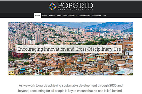
Professor Stefan Leyk of the University of Colorado organized and led a virtual workshop November 30, “Gridded Population Data for the Sustainable Development Goals,” for experts from Colombia's National Administrative Department of Statistics (DANE) and Paraguay's General Directorate of Statistics, Surveys, and Censuses (DGEEC). The workshop provided an overview of the development and sources of gridded population data, hands-on technical training in working with selected data, and a forum for obtaining feedback on user needs. CIESIN Director Robert Chen gave introductory remarks during the opening session, and in the final session research scientist Susana Adamo provided an update in Spanish on progress and plans for the fifth version of the Gridded Population of the World (GPW) data set. Associate director for Science Applications Alex de Sherbinin, associate director for Geospatial Applications Greg Yetman, and research staff assistant Juan Martinez also attended. The workshop was organized by Leyk and Maryam Rabiee of the Thematic Research Network on Data and Statistics (TReNDS) of the United Nations Sustainable Development Solutions Network (SDSN), under the auspices of the POPGRID Data Collaborative. Funding for the workshop was provided by Deutsche Gesellschaft für Internationale Zusammenarbeit (GIZ) GmbH. POPGRID is an initiative launched by CIESIN in 2017 to bring together both developers and users of global georeferenced population data in support of development applications. POPGRID activities and resources are supported in part by the Bill & Melinda Gates Foundation and the NASA Socioeconomic Data and Applications Center (SEDAC). Leyk is also a member of SEDAC′s User Working Group.
|
|
CIESIN Highlights the Power of Geographic Information Systems on GIS Day
|
|
November 19, 2020
CIESIN experts helped to celebrate GIS Day as part of several events held virtually on November 18. For a “Lunch and Learn” Webinar organized by NASA and Esri, Greg Yetman, associate director for Geospatial Applications, gave a 10-minute talk on how geographic information systems (GIS) facilitates the integration of socioeconomic and biophysical data to support interdisciplinary research and applications. He noted CIESIN’s long history in developing gridded population data products, extending back more than 25 years when GIS software was still in its infancy. Later in the day, CIESIN and the New York City (NYC) Geospatial Information System and Mapping Organization (GISMO) held the online event, “Discover the World Through GIS in NYC.” The event featured presentations by students and researchers from CIESIN and Columbia University, Lehman College of the City University of New York, and the New York City Housing Authority (NYCHA). Nearly 80 people from around the world learned about efforts to map the movement of refugees and COVID-19; plan for disaster housing; evaluate bike paths in the Bronx; implement interactive mapping in the NYCHA; and prioritize tiger habitats in India’s wildlife corridors. The event was hosted by senior geographic information specialist Dara Mendeloff, in coordination with senior geographic information specialist Tricia Chai-Onn. Mendeloff is a member of the Board of Directors of GISMO, a volunteer organization founded in 1990.
See: “Discover the World Through GIS in NYC” (link available through December 9)
|
|
Interactive Data Hubs Help Support Countries’ COVID-19 Responses
|
|
November 17, 2020
|
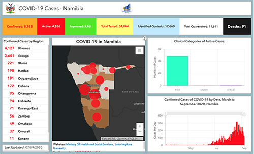
| COVID-19 data hub for Namibia. Country-specific hubs for Namibia, Nigeria, Sierra Leone, and Zambia have data on hospitals and isolation centers, population distribution in COVID-19 epicenters, and risk factors associated with COVID-19. |
Publicly accessible, user-friendly data hubs to support COVID-19 response efforts in several African countries have been developed in close partnership with national government agencies and other stakeholders. Vital components in the leveraging of these countries’ commitment and capabilities in containing the pandemic, the hubs consolidate relevant geospatial data from a variety of sources. Country-specific hubs for Namibia, Nigeria, Sierra Leone, and Zambia are currently available and include data on hospitals and isolation centers, population distribution in COVID-19 epicenters, and risk factors associated with COVID-19. The hubs also provide data visualization tools and dashboards, Web applications and interactive maps, and access to data and documentation, developed collaboratively with agencies and stakeholders. Technological support from private sector organizations Esri and Fraym was coordinated by CIESIN’s Geo-Referenced Infrastructure and Demographic Data for Development (GRID3) program. Olena Borkovska, geographic information specialist, has been coordinating technical assistance for the hub for Zambia. Other staff supporting in-country partners and stakeholders are project coordinator Justine Dowden (Namibia), senior research associate Emilie Schnarr (Nigeria), and senior research staff assistant Annie Werner (Sierra Leone).
|
|
Updates to Sustainability Indicators Released
|
|
November 16, 2020
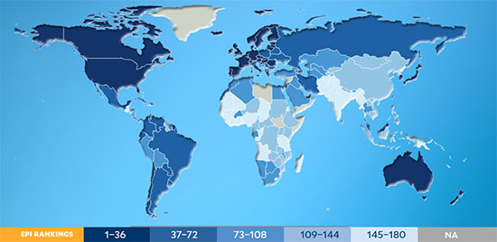
CIESIN has recently released the preliminary 2020 version of the Natural Resource Protection and Child Health Indicators (NRPI and CHI) in support of the country selection process conducted by the Millennium Challenge Corporation (MCC). The MCC bases its selection criteria for foreign assistance on a variety of quantitative governance, social, economic, and environmental indicators, including the NRPI and CHI. The USAID has also begun utilizing the CHI in 2020 to chart progress on the Journey to Self-Reliance, an initiative that fosters sustained self-reliance on the part of developing countries. The NRPI assesses whether a country is protecting at least 17% of all of its biomes (e.g., forests, grasslands, aquatic ecosystems, and tundra). The CHI incorporates three underlying indicators—Access to At Least Basic Sanitation, Access to At Least Basic Water, and Child Mortality, ages 1–4—and serves a useful proxy for key environmental conditions. The 2020 version of the Environmental Performance Index (EPI), developed by the Yale Center for Environmental Law & Policy and CIESIN, has also been released. The EPI ranks 180 countries in two major components, environmental health and ecosystem vitality, based on 32 indicators. Produced every two years since 2006, the EPI is archived and disseminated by the NASA Socioeconomic Data and Applications Center (SEDAC) managed by CIESIN. The 2020 release includes a report, data sets for download, and an extensive map gallery of nearly 100 maps visualizing changes in performance over more than two decades.
See: 2020 Natural Resource Protection and Child Health Indicators (NRPI and CHI)
2020 Environmental Performance Index
|
|
Research Data Alliance Focuses on “Knowledge Ecology” at its Virtual 16th Plenary
|
|
November 13, 2020
Senior digital archivist Robert Downs participated in the 16th Plenary meeting of the Research Data Alliance (RDA P16) held virtually November 9–12. The meeting, which was organized by CONARE Costa Rica, RDA United States, and Research Data Canada, had the theme, “Knowledge Ecology,” focusing on how open science can support the diversification, expansion, reuse, and constant creation of knowledge, as in healthy ecological systems. On November 9, Downs led the joint breakout session of the Repository Platforms for Research Data Interest Group (IG) and the Domain Repositories IG, “Approaches for Selecting Research Data Repository Platforms and Sharing Resources to Facilitate Open Science.″ During this session, he gave two presentations, “Selecting Research Data Repository Platforms for Open Science,” and “Opportunities for Sharing Resources among Research Data Repositories.” Downs also presented the poster, “Simultaneously Leveraging Principles to Improve Capabilities for Using Research Data,” as part of the P16 poster session. Recordings from RDA P16 are now available online to meeting registrants. The RDA was established in 2013 as an international community of data experts and users. It now has more than 10,000 members from more than 145 countries.
|
|
Collaboration with Lehman College Launched to Develop Hazards Data
|
|
November 12, 2020
CIESIN has developed a collaboration with the Department of Earth, Environmental, and Geospatial Sciences at Lehman College of the City University of New York to develop and enhance hazards data, working initially with five Lehman graduate and undergraduate students. Supervised by CIESIN alumnus Yuri Gorokhovich, associate professor in the Department, the students are Christopher Aime, Diana Calderón, Nira Rahman, and Raychell Velez from Lehman's Master′s program in Geographic Information Science; and Hadja Doumbouya, a senior majoring in environmental sciences. CIESIN associate director for Geospatial Applications Greg Yetman is assisting the students in using machine learning methods to develop improved data on the exposure and vulnerability of buildings and other infrastructure to hazards, extending recent work for the State of New York supported by the New York State Energy Research and Development Authority (NYSERDA). Carolynne Hultquist, CIESIN postdoctoral research scientist, and Andrew Kruczkiewicz, senior staff associate at the International Research Institute for Climate and Society (IRI), are also working with the students to apply the data to flash flood hazard assessment. The collaboration is supported by the NASA Socioeconomic Data and Applications Center (SEDAC) as part of SEDAC's efforts to achieve small business purchasing goals established by NASA, which include collaboration with Minority Serving Institutions (MSIs) and Historically Black Colleges and Universities (HBCUs). Outputs of the collaboration will be made available via SEDAC after appropriate review. Based in the Bronx, Lehman is one of the only MSIs (or HBCU′s) in the US to offer a master of science degree in geographic information science.
|
|
Recent Webinars Highlight Tools and Data for COVID-19 and Public Health Planning
|
|
November 4, 2020
The Global COVID-19 Viewer developed by the NASA Socioeconomic Data and Applications Center (SEDAC) operated by CIESIN was the subject of the first NASA Earthdata Webinar of fiscal year 2021, “SEDAC’s Global COVID-19 Viewer: A User-Friendly Tool for Assessing National and Subnational Trends and Risk Factors in Coronavirus Spread.” The October 28 webinar was given by Alex de Sherbinin, SEDAC deputy manager and CIESIN associate director for Science Applications, and Joe Schumacher, SEDAC user services manager and CIESIN senior information specialist. Approximately 110 participants learned about the development of the Viewer, launched in March 2020 and updated most recently in September. The Webinar included a live demonstration of the Viewer, which lets users visualize spatially-explicit trends in COVID-19 infection and mortality rates, including daily updated global data on COVID-19 cases and deaths in relationship to population density and key risk factors. The demo focused on current hotspots, interesting trends, and an exploration of risk factors. On November 2, Jolynn Schmidt, program manager-data lead for the Geo-Referenced Infrastructure and Demographic Data for Development (GRID3) program managed by CIESIN, participated in a workshop at the 7th 2020 GeONG Forum, a virtual gathering of international humanitarian and development organizations. The workshop focused on different approaches and lessons learned in defining health catchment areas and assessing the number of people in them, which is important for estimating the potential number of patients and demand on health facilities. Schmidt presented her experience working to strengthen developing countries’ capabilities for mapping population distribution, human settlements, and other core spatial data layers.
See: "SEDAC’s Global COVID-19 Viewer" (Adobe Connect recording)
|
|
CIESIN Scientists Address Climate-Migration Linkages and Open Data Policies
|
|
October 23, 2020
Alex de Sherbinin, associate director for Science Applications, recently published the feature article, “Impacts of Climate Change as Drivers of Migration,” in Migration Information Source, the online journal of the Migration Policy Institute. The article reviews the growing evidence base for environmentally induced migration, summarizes key lessons learned, and assesses implications for future migration under climate change. Climate-migration linkages have also been the focus of a number of recent events. On October 21, de Sherbinin gave a presentation, “Climate Change and Its Impacts on (Well Being), Migration, and Displacement,” to the Virtual Global Climate Change Seminar Series of the Weill Cornell Medicine Global Health Education program. He also moderated a virtual panel, “Climate, Conflict, and Coronavirus: A Perfect Storm for Migrants and Displaced Persons,” October 22. Panelists included Jeffrey Schlegelmilch, director of the National Center for Disaster Preparedness; Kamal Amakrane, director in the Office of the President of the 71st Session of the United Nations General Assembly (UNGA); and Leslie Roberts, associate professor of Population and Family Health and a member of the Program on Forced Migration and Health at Columbia′s Mailman School of Public Health. This was one of a series of panels organized by the Committee on Forced Migration, an initiative of the Columbia Global Centers. CIESIN director Robert Chen presented approaches to open data access by the Earth observations and research communities during an online stakeholder consultation organized October 21 by the World Meteorological Organization (WMO). Conclusions and recommendations from the session are being submitted as inputs to the WMO Data Conference, to be held virtually November 16–19. The WMO Data Conference is seeking to develop a common understanding across all sectors of society on the roles, requirements, and arrangements needed for international exchange of observations and other data for monitoring and prediction of the Earth System environment, including weather, climate, and water.
See: “Impacts of Climate Change as Drivers of Migration” (article)
“Climate, Conflict, and Coronavirus: A Perfect Storm for Migrants and Displaced Persons” (panel)
WMO Stakeholder Consultation 2: Research data and WMO data policy (video)
WMO Stakeholder Consultation 2: Research data and WMO data policy (key messages)
|
|
United Nations Holds Virtual Forum to Promote Cooperation on Sustainable Development Data
|
|
October 23, 2020
The 2020 United Nations (UN) World Data Forum was held virtually October 19–21, in place of a physical meeting in Bern, Switzerland, that has been postponed to 2021. The Forum serves as a platform for intensifying cooperation on sustainable development data across a diverse set of communities, under the auspices of the UN Statistical Commission. Several CIESIN staff participated actively in the Forum. On October 20, Sandra Baptista, senior research associate, and Andrea Jordan, special assistant to the deputy director, both representing the Geo-Referenced Infrastructure and Demographic Data for Development (GRID3) program, co-organized the live panel, “Use of Geospatial Data to Support COVID-19 Response,” with Colombia’s National Administrative Department of Statistics (DANE). The panel was moderated by Io Blair-Freese of the Bill & Melinda Gates Foundation and included two partners in the GRID3 program: Prince Clem Ikanade Agba, minister of state for budget and national planning of the Federal Republic of Nigeria and co-chair of GRID3′s Nigeria national steering committee; and David Moinina Sengeh, minister of basic and senior secondary education and chief innovation officer for the Government of Sierra Leone. The Forum also included a number of pre-recorded sessions. NASA, UN-Habitat, the European Space Agency, and the Group on Earth Observations (GEO) organized a session on the use of Earth observations to make cities inclusive, safe, resilient, and sustainable. CIESIN Director Robert Chen co-authored a short presentation with Thomas Kemper of the European Commission′s Joint Research Centre on behalf of the GEO Human Planet Initiative, which he co-leads. They also participated in a pre-recorded question-and-answer session. Recordings of Forum sessions are now available online. The UN World Data Forum was originally established in response to a key recommendation in the 2014 report, “A World that Counts: Mobilising the Data Revolution for Sustainable Development,″ prepared by the UN Secretary-General′s Independent Expert Advisory Group on a Data Revolution for Sustainable Development.
See: “Use of Geospatial Data to Support COVID-19 Response” (panel)
“Tools to...Use Earth Observations to Deliver SDG 11 and the New Urban Agenda″ (panel)
|
|
CIESIN Supports First-Ever Virtual Lamont Open House
|
|
October 22, 2020
The free Lamont Open House has been held nearly every year since 1949, attracting thousands of students, families, and other interested individuals who live near the Lamont campus and the broader New York metropolitan area. Due to COVID-19 restrictions, the 2020 Open House shifted to a virtual format, “Lamont Open House at Home,″ held online October 19–21. Several CIESIN staff members contributed to the event, which aimed to encourage awareness and interest in the earth sciences and to emphasize how better understanding of the Earth can help preserve its future. Dara Mendeloff, senior geographic information specialist, was one of three speakers in the panel, “When am I Going to Use This? Dynamic Careers in Science,” October 19. During the panel, which was geared to students in grade 6–12, she shared her experience as a geospatial information science researcher, beginning with her early interest in environmental issues in high school and continuing with her training in and use of geographic information system (GIS) tools, data, and methods. She also highlighted a range of CIESIN mapping tools and projects and participated in the question-and-answer session. A recording of the panel is now available on YouTube. Justine Dowden, project manager with the Geo-Referenced Infrastructure and Demographic Data for Development (GRID3) program, was moderator and Emilie Schnarr, GRID3′s country manager for Nigeria, was one of two panelists for the October 20 session, “Fighting Disease with Geospatial Data and Climate Prediction.″ The session highlighted novel approaches to improve public health by using better data and forecasts to improve planning for outbreaks of mosquito-borne diseases and for vaccination campaigns that need to reach all vulnerable populations. Ángel G. Muñoz, associate research scientist at the International Research Institute for Climate and Society (IRI) was the other panelist. CIESIN staff have participated regularly in the Lamont Open House, since CIESIN′s move to the Lamont campus in 1998 to become part of the Earth Institute.
See: ″When am I Going to Use This?: Dynamic Careers in Science” (video—presentation begins at 23:45)
″Fighting Disease with Geospatial Data and Climate Prediction” (abstract)
|
|
New Data on Food Insecurity 2009–2019 and Settlement Extents in Africa Released
|
|
October 19, 2020
CIESIN has developed and released several new data sets recently. Now available from the NASA Socioeconomic Data and Applications Center (SEDAC) is the Food Insecurity Hotspots data set, which consists of gridded data identifying the level of intensity and frequency of food insecurity over ten years between 2009 and 2019, as well as hotspots of consecutive food insecurity events. The data set covers five regions: Central America and the Caribbean, Central Asia, East Africa, Southern Africa, and West Africa. The grids are at 250 meter (~7.2 arc-seconds) resolution and are based on subnational food security analyses for these regions provided by the Famine Early Warning Systems Network (FEWS NET). FEWS NET was established in 1985 by the U.S. Agency for International Development (USAID). As part of the Geo-Referenced Infrastructure and Demographic Data for Development (GRID3) program managed by CIESIN, data on operational settlement points and/or boundaries, health facilities, and points of interests have been released for Zambia and the Democratic Republic of the Congo. Settlement extent data are now available for 41 African countries, created from Digitize Africa building footprints powered by Maxar. GRID3 has expedited settlement extent mapping to support countries in their COVID-19 response efforts. The data are broadly intended to support country decision-making in public health and education.
See: Food Insecurity Hotspots Data Set, v1 (2009 – 2019)
GRID3 Data Available through Columbia Academic Commons
|
|
Members of the International Science Council World Data System Meet Virtually
|
|
October 16, 2020
The World Data System (WDS) of the International Science Council (ISC) held its 2020 Members Forum online on September 23. CIESIN associate director of Science Applications Alex de Sherbinin, in his capacity as chair of the WDS Scientific Committee, helped organize and chair the Forum and gave a presentation on the issue of generalist versus domain-specific repositories. CIESIN director Robert Chen chaired a panel session, “Sustainability: Making the Case for Domain Repositories through Value of Information, Operational Use, and Web Services.” As manager of the NASA Socioeconomic Data and Applications Center (SEDAC), which is a regular member of WDS, Chen also pre-recorded a lightning presentation on SEDAC′s strategic goals and plans. Other Forum participants included senior digital archivist Robert Downs and research scientist Susana Adamo, as well as representatives from several other NASA Distributed Active Archive Centers (DAACs) and from NASA′s Earth Science Data and Information System (ESDIS) Project, which is a network member of the WDS. In conjunction with the Forum, the International Symposium: Global Collaboration on Data Beyond Disciplines was held September 23–25. A plenary session to commemorate the 10th anniversary of the hosting of the WDS International Programme Office (WDS-IPO) by the Japanese National Institute of Information and Communications Technology (NICT) included pre-recorded remarks given by de Sherbinin on behalf of the WDS Scientific Committee. CIESIN remains active in several different WDS activities. For example, Downs is a member of the WDS Harvestable Metadata Services (HMetS) Working Group and de Sherbinin co-leads the joint CODATA-WDS Citizen Science for the SDGs Task Group. He also chaired the virtual meeting of the WDS Scientific Committee on October 13–15.
See: “World Data System Domain Specific versus Generalist Repositorie” (PDF 225 KB)
“SEDAC Goals and Plans” (2.5 minute video)
Members Forum Videos
|
|
Visiting Scholar Wraps Up Urbanization Research at CIESIN
|
|
October 9, 2020
Ju He, a PhD candidate in land resource management, has completed a one-year visit at CIESIN, during which he conducted research on the transformation of urban land and population in Chinese megacities. CIESIN director Robert Chen and information scientist Xiaoshi Xing served as his foreign supervisors. Ju He is from the School of Public Affairs of Zheijiang University in Hangzhou, China. He gave an online presentation, “Urban Human-Land Relationship Change in China from the Perspective of the Transformation of Urbanization,” to CIESIN staff and other interested experts on October 8.
|
|
New Paper on Links between Religion and the Environment
|
|
October 2, 2020
Alex de Sherbinin, CIESIN associate director for Science Applications, Susana Adamo, research scientist, and Tricia Chai-Onn, senior geographic information specialist, are co-authors of a new study on the link between environmental challenges and religion, published in the Journal of Religion and Demography. Vegard Skirbekk of Columbia University's Mailman School of Public Health is lead author. The paper, “Religious Affiliation and Environmental Challenges in the 21st Century,” builds on a growing body of research carried out at the Columbia Aging Center, where researchers analyzed religious affiliation together with a variety of environment and climate change-related indicators at the country level.
See: “Religious Affiliation and Environmental Challenges in the 21st Century”
“How Religion Influences Our Environment” (blog)
|
|
GRID3 Program Names Deputy Director
|
|
September 28, 2020
CIESIN senior research associate Paola Kim-Blanco has been appointed deputy director of the Geo-Referenced Infrastructure and Demographic Data for Development (GRID3) program. GRID3 aims to strengthen developing countries’ capabilities for mapping population distribution, human settlements, and other core spatial data layers, enhancing the scope and efficacy of development efforts. In her role as deputy director, Kim-Blanco assists Marc Levy, CIESIN deputy director and principal investigator of GRID3, in strategic planning and development. In collaboration with partner organizations and donors, she also helps coordinate work plans for participating countries, including Burkina Faso, Democratic Republic of the Congo, Mozambique, Namibia, Nigeria, Sierra Leone, Somalia, South Sudan, and Zambia. During her ten years at CIESIN. Kim-Blanco has contributed to other major development projects such as the Haiti Regeneration Initiative/Cote Sud Initiative (HRI/CSI), and the Millennium Villages Project (MVP). From Columbia University, her degrees include an MA in quantitative methods for the social sciences, and a master of international affairs. She holds an MS in sustainable development and a BA in architecture, from Tecnologico de Monterrey, in Mexico City. GRID3 is managed by CIESIN and funded by the Bill & Melinda Gates Foundation; the United Kingdom's Foreign, Commonwealth & Development Office (formerly DfID); and Gavi, the Vaccine Alliance.
|
|
Updated COVID-19 Map Viewer Shows Daily and 7-Day Trends at a Glance
|
|
September 25, 2020
|
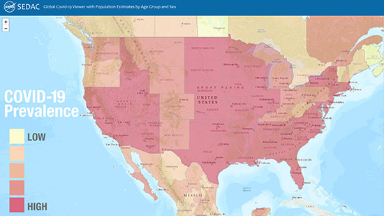
| The Global COVID-19 Viewer map from September 25 shows the prevalence of COVID-19 cases, defined as the total number of cases per 100,000 people, for the United States and parts of Canada and Mexico since early in the pandemic. |
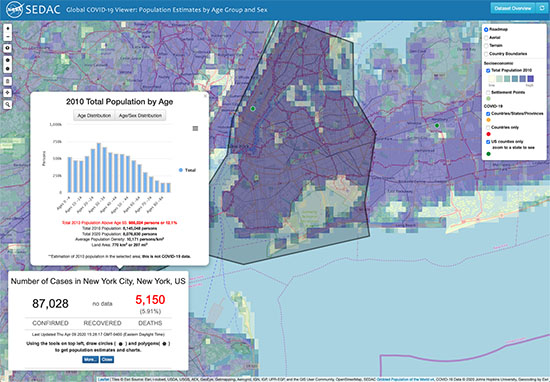
The latest update to the Global COVID-19 Viewer: Population Estimates by Age Group and Sex features enhanced capabilities for visualizing the status and reach of the pandemic around the world, daily and over time since its beginning, and to identify at-risk populations. A pop-up trends graph illustrates daily and 7-day moving averages of COVID-19 cases and deaths for a range of select time scales—one month, three months, six months, and beyond. The graph may be accessed by simply clicking on a country. User-friendly mapping tools let users define a custom area or fly to a location of interest. Users may also easily move up or down administrative levels in many countries and view demographic and urbanization estimates relevant to possible risk factors for the virus. The Viewer was developed by the NASA Socioeconomic Data and Applications Center (SEDAC) managed by CIESIN. The underlying population data are from SEDAC′s Gridded Population of the World (GPW) Basic Demographic Characteristics, v4.11, for the year 2010, with estimates to 2020. The COVID-19 data are from Johns Hopkins University & Medicine Coronavirus Resource Center.
See: SEDAC Global COVID-19 Viewer
|
|
CIESIN Staff Participate in Virtual Meetings on Key Data Issues
|
|
September 24, 2020
During August and September, CIESIN scientists contributed to numerous online meetings and Webinars focused on diverse issues related to citizen science data, data quality and stewardship, geospatial data development and applications, and climate migration modeling and data. Senior digital archivist Robert Downs gave the presentation, “Improving Data Stewardship Based on the TRUST Principles for Digital Repositories,” at the #WeMissiPRES virtual meeting on 23 September. The annual International Conference on Digital Preservation (iPRES) was cancelled due to the COVID-19 pandemic, and was replaced by a virtual event consisting of three half-day sessions September 22–24. Downs′ presentation focused on the ongoing implementation of the TRUST Principles (transparency, responsibility, user focus, sustainability, and technology) at the NASA Socioeconomic Data and Applications Center (SEDAC) operated by CIESIN. Downs also presented, “NASA Socioeconomic Data and Applications Center (SEDAC): Current Status, Road Map and Challenges,″ during a virtual meeting of the World Data System (WDS) Harvestable Metadata Services (HMetS) Working Group on September 9. Alex de Sherbinin, associate director for Science Applications, gave the talk, “Data for the Sustainable Development Goals in Africa: The role of citizen-generated data,” at a Technical Validation Workshop on September 16 for the project, Standardizing City-Level Data-Gathering for Achieving Sustainable Development Goal 11 in Africa (SCiLeD). On 14 September, he also served as a panelist during the 2020 Global Shifts Colloquium, organized by the Perry World House at the University Pennsylvania, where he presented work on climate migration modeling and data sources. August 26–27 and September 4, CIESIN participated as an observer organization in the virtual Tenth Session of the United Nations Group of Experts on Global Geospatial Information Management (UN-GGIM). CIESIN′s delegation was led by director Robert Chen. The UN-GGIM promotes international collaboration on geospatial data and information and reports on all matters relating to geography, geospatial information, and related topics to the UN Economic and Social Council (ECOSOC). CIESIN has been a non-governmental organization with special consultative status recognized by ECOSOC since 1995. At the 2020 Earth Science Information Partners (ESIP) Summer Meeting Highlights Webinar on August 13, Robert Downs gave a lightning talk summarizing the ESIP Information Quality Cluster session, “Citizen Science and Data Quality.” The Webinar provided an overview of plenary and breakout sessions from the Summer Meeting, and is available for viewing on YouTube.
|
|
New Publications Released on Climate Risk, Citizen Science Data, Data Quality, and Boundary Data
|
|
September 19, 2020
Alex de Sherbinin, associate director for Science Applications, is guest editor of a special Issue of the journal Sustainability on climate risk and vulnerability mapping, with co-editor Stefan Kienberger of the University of Salzburg. He is also a co-author of one of the papers in the special issue, on using flood disaster data to validate components of social vulnerability to floods. The paper’s lead author is Earth Institute Fellow Beth Tellman. The article, “Still in Need of Norms: The State of the Data in Citizen Science,″ has been published in the journal Citizen Science: Theory and Practice. Anne Bowser of the Wilson Center is lead author, and de Sherbinin is a co-author. The article is a major output of the CODATA-World Data System (WDS) Task Group on Citizen Science and the Validation, Curation, and Management of Crowdsourced Data, which de Sherbinin co-chaired in 2016-2018. Senior digital archivist Robert Downs is a co-author of the report, “Laying the Groundwork for Developing International Community Guidelines to Effectively Share and Reuse Digital Data Quality Information—Case Statement, Workshop Summary Report, and Path Forward,” published in Open Science Foundation (OSF) Preprints. Ge Peng of the Earth Science Information Partners (ESIP) Information Quality Cluster is lead author. The report, which stems from a pre-workshop held in July 2020 prior to the ESIP Summer Meeting, describes the approach that will be taken to develop community guidelines for preparing and sharing data quality information. The Geo-Referenced Infrastructure and Demographic Data for Development (GRID3) program managed by CIESIN has released the white paper, “Harmonizing Subnational Boundaries,” on GRID3 efforts to support the harmonization, production, and use of digitized legal/administrative units, operational units, and statistical areas. This work addresses three primary areas: improving and harmonizing operational units; fostering improved collaboration on boundary harmonization among disparate government bodies; and using boundaries harmonization to support census efforts. The paper focuses on case studies in Nigeria, the Democratic Republic of the Congo, and Zambia.
See: Special Issue: “Climate Risk and Vulnerability Mapping″
Paper: “Using Disaster Outcomes to Validate Components of Social Vulnerability to Floods: Flood Deaths and Property Damage across the USA″
Paper: “Still in Need of Norms: The State of the Data in Citizen Science″
Report: “Laying the Groundwork for Developing International Community Guidelines to Share and Reuse Digital Data Quality Information—Case Statement, Workshop Summary Report, and Path Forward
White Paper: “Harmonizing Subnational Boundaries”
|
|
NASA Data Flows Even When the World Is Telecommuting
|
|
September 4, 2020
NASA recently published an article on its Earthdata web site about the continued flow of NASA Earth science data during the global COVID-19 pandemic. The article describes how the overall Earth Observing System Data and Information System (EOSDIS) was able to continue processing and distributing many terabytes of data each month even though NASA centers had closed and almost all staff had to shift to remote work. The article also highlights how two of the twelve NASA Distributed Active Archive Centers (DAACs)—the Alaska Satellite Facility DAAC operated by the University of Alaska, and the Socioeconomic Data and Applications Center (SEDAC) operated by CIESIN—have adapted to the changing work environment. CIESIN director Robert Chen, who has served as SEDAC's manager for more than 20 years, noted that this is not the first time that SEDAC has faced major disruptions (9/11 in 2001 and Superstorm Sandy in 2012). Among other efforts, SEDAC has worked to increase virtualization of its systems to strengthen flexibility and reliability. NASA recently exercised another option year in CIESIN's contract to continue operating SEDAC (through July 2021). CIESIN received an “exceptional″ performance rating from NASA for the option year that ended in July 2020.
See: Keeping NASA EOSDIS Data Flowing (Even When the World is Telecommuting)
|
|
New Earth Institute Fellow to Study Extreme Heat Events and Their Impacts
|
|
September 4, 2020
Cascade Tuholske has joined CIESIN for a two-year appointment as an Earth Institute postdoctoral research scientist. Tuholske is a geographer specializing in the integration of global-scale human and environment geospatial data to examine the relationship between urbanization and climate change. At CIESIN, he has begun working with director Robert Chen and associate director for Science Applications Alex de Sherbinin to construct a globally extensive, longitudinal, and fine-scale synthesis of extreme heat events, urban population growth, and the urban heat island effect. His goal is to inform adaptation strategies that reduce the harmful and inequitable impacts of urban exposure to extreme heat. He will also contribute to another NASA-funded project on the use of gridded population and settlement datasets to assess progress towards the United Nations Sustainable Development Goals (SDGs). Tuholske received his PhD in geography from the University of California, Santa Barbara, where he focused on the nexus of climate change, urbanization, and food security in Africa under the guidance of Prof. Kelly Caylor.
|
|
Bilingual Videos Provide Training on Integrating Spatial Data
|
|
August 25, 2020
The Population-Environment Research Network (PERN) has released several online training modules in English and Spanish on the fundamentals of spatial data integration, geared towards demographers and other population researchers. Developed by Susana Adamo, CIESIN research scientist, and Professor Landy Sanchez of the Center for Demographic, Urban, and Environmental Studies at El Colegio de Mexico (COLMEX), the video-based tutorials draw on pre-packaged data and open source geographic information system (GIS) and Web-based tools. The goals of the online training are to review the fundamentals of spatial data integration, with an emphasis on remote sensing; present an overview of relevant datasets and services (platforms and tools); develop basic skills for linking demographic and environmental data; and expand the use of specialized data sources. Production was supported by the International Union for the Scientific Study of Population (IUSSP) through a grant from the William and Flora Hewlett Foundation. PERN is a scientific panel of IUSSP and a sustained partner of Future Earth, and is hosted by the NASA Socioeconomic Data and Applications Center (SEDAC) managed by CIESIN. Adamo is co-coordinator of PERN and SEDAC′s lead project scientist; Sanchez is former chair of the PERN Scientific Committee.
See: bilingual training modules
|
|
Summer Brings More CIESIN Staff Changes
|
|
August 6, 2020
Data and program analyst Jolynn Schmidt has been promoted to program manager-data lead for CIESIN’s Geo-referenced Infrastructure and Demographic Data for Development (GRID3) program. The promotion recognizes her increased responsibilities for managing geographic information systems (GIS) activities and systems implementation with a growing team of GIS specialists. GRID3 is addressing challenging problems in a range of African countries, including new efforts driven by responses to the COVID-19 pandemic. Schmidt has a master of geographic information systems degree from Pennsylvania State University. Former student intern Juan Martinez has been hired as a research staff assistant in CIESIN’s Information Technology division, working with Kytt MacManus, senior systems analyst/GIS developer, on the development of nighttime lights data and mapping services. Martinez earned his BA in sustainable development from Columbia’s School of General Studies, after completing an AA in liberal arts from Borough of Manhattan Community College. Research staff assistant Rya Inman has accepted a teaching fellowship at Loyola University, where she will work towards a master′s in education. Inman has supported MacManus on a variety of CIESIN projects and served as his teaching assistant for several semesters. Inman graduated from the dual BA program between Columbia University and Sciences Po Paris, majoring in social sciences and earth science.
|
|
CIESIN Alumna Appointed Director of Institute for Demographic Research at City University of New York
|
|
August 4, 2020
Former CIESIN scientist Deborah Balk has assumed the directorship of the Institute for Demographic Research (IDR) at the City University of New York (CUNY). She had served as IDR′s associate director since 2006. Balk is also professor of public affairs at the Austin W. Marxe School of Public and International Affairs at Baruch College. She serves on several noteworthy committees, including the National Research Council (NRC) Committee on Population, the U.S. Census Bureau’s Scientific Advisory Committee, and the New York City Panel on Climate Change, for which she is a co-chair. She was an Andrew Carnegie Fellow 2016–2018. Her research focus is urbanization in the developing world, using a spatial framework to explore the demographic implications of climate-change issues. Balk is currently working with Kytt MacManus, senior systems analyst/GIS developer at CIESIN, and with Gordon McGranahan of the Institute of Development Studies in the United Kingdom, on updates to the low-elevation coastal zone estimates developed in a 2007 study. She was lead project scientist for the NASA Socioeconomic Data and Applications Center (SEDAC) operated by CIESIN from 1998 to 2006, spearheading the development of many widely-used population-related data products and services. She later served as a member of SEDAC′s User Working Group (UWG) 2015–2018.
|
|
Earth Institute Scientists Bring Climate Change Learning into the Classroom
|
|
July 31, 2020
Senior geographic information specialist Dara Mendeloff joined Earth Institute experts on climate and sustainability issues in a live online professional development event for K–12 educators sponsored by the Earth Institute July 28–29. The event, “E.I. Teach: Climate Change in the Classroom,” emphasized project-based learning, providing educators with the tools and content to address climate change in their classroom curricula using dynamic hands-on and interactive learning approaches. Mendeloff’s session, “Get the GIS of Climate Change,” demonstrated how educators can use geographic information system (GIS) tools available through the Esri cloud-based service ArcGIS Online, to analyze data on sea level rise, coastal flooding, and storm surge in New York City, gaining insight into the intersection of socioeconomic and climate issues. Other presenters at the event included Jason Smerdon, Nichole Anest, and Margie Turrin of the Lamont-Doherty Earth Observatory. The event was aimed at educators focused on grades 6–12 on the first day, and K-5 on the second day. Participants received a certificate following completion of the relevant workshop.
See: “EI Teach” for K-12 Educators
|
|
Symposium Offers Multi-Disciplinary Retrospective on Planetary Health
|
|
July 30, 2020
Established in 2011, the World Wide Human Geography Data (WWHGD) Working Group provides a platform for the discussion of human geography issues and sharing of human geography data. In recognition of its long track record of conferences and webinars, the WWHGD organized a 50th Retrospective Symposium on the topic of planetary health, an all-day online event on July 29 that brought together many of the experts who had presented at one or more prior WWHGD events. CIESIN associate director for Science Applications Alex de Sherbinin was invited to speak about climate and human geography in the session, “A Conversation on Environmental Change Impacts.” CIESIN director Robert Chen participated in the closing panel on strategic human geography perspectives and solutions for future challenges. The Symposium highlighted a diverse set of data and information resources related to human security and planetary health, including a number of data sets and tools provided by CIESIN through the NASA Socioeconomic Data and Applications Center (SEDAC) and other CIESIN projects. Co-led by the National Geospatial-Intelligence Agency and the US Department of State, the WWHGD Working Group has nearly 5,000 members spread across more than 150 countries.
|
|
Earth Science Information Partners Gather Online to Explore Public-Private Partnerships
|
|
July 25, 2020
The 2020 Summer Meeting of the Earth Science Information Partners (ESIP) was held virtually July 14–24, rather than in Burlington, Vermont, as originally planned. The meeting theme was “Putting Data to Work: Building Public-Private Partnerships to Increase Resilience & Enhance the Socioeconomic Value of Data.” In line with the theme, CIESIN collaborated with ISciences LLC, CASE Consultants international, and the U.S. Army Corps of Engineers (USACE) to organize two linked sessions July 23 on open source environment-security analytics. The first session featured talks by CIESIN alumnus Tom Parris, president of ISciences; Mark Wahl of the USACE Engineer Research and Development Center (ERDC); and CIESIN director Robert Chen. Chen highlighted numerous public-private partnerships involving CIESIN over more than two decades, including diverse initiatives dealing with environment-security crises, disaster risk management, climate change, and population data. In the second session, senior systems analyst/GIS developer Kytt MacManus led a hands-on subgroup, “Employing Python and R for Explorations of Gridded Demographic Data using Web Services.” Other technical subgroups were led by ISciences and ERDC staff, building in part on a USACE-funded Small Business Technology Transfer Research (STTR) project to develop Data ANalytics and Tools for Ecosecurity (DANTE). Senior digital archivist Robert Downs was also very active in the ESIP summer meeting. He co-organized the pre-meeting workshop, “Developing Community Guidelines for Consistently Curating and Representing Dataset Quality Information,” and gave a presentation, “GEOSS Data Management and Data Sharing Principles and TRUST,” on July 13. He co-organized the sessions, “Exploring New Perspectives and Formulating Best Practices for Data Uncertainty Information (Parts 1 & 2)” offered July 15, and “Citizen Science Data and Information Quality” and “Challenges of Consistently Curating and Representing Fair Dataset Quality Information,” held July 22. During the Live Research Showcase sessions July 17 and 23, he presented the poster, “Meeting the Challenges of the TRUST Principles for Digital Repositories.” He also arranged for a number of mapping tools developed by the NASA Socioeconomic Data and Applications Center (SEDAC) to be demonstrated and reviewed by teachers in the 2020 ESIP Teacher Workshop, “Putting Data to Work for Earth Science Education,” July 14 and 15. SEDAC is a Type I member of ESIP.
See: 2020 ESIP Summer Meeting
|
|
CIESIN’s GRID3 Program Welcomes New Staff and Interns
|
|
July 24, 2020
CIESIN welcomes a new project coordinator, Emily Boytinck, to its Geo-Referenced Infrastructure and Demographic Data for Development (GRID3) program, along with a team of undergraduate interns from the Geospatial Evaluation and Observation Laboratory (geoLab) of the College of William and Mary who are supporting the lab’s geoBoundaries project. Working with senior research associate Paola Kim-Blanco, Boytinck is coordinating activities and stakeholder engagement for the Democratic Republic of the Congo (DRC). She has an MPA in development practice from Columbia University. Six interns from the College of William and Mary have begun working remotely on data processing and related activities for the DRC, Ethiopia, Sierra Leone, and Zambia, under the supervision of geoLab′s faculty director Dan Runfola and CIESIN data and program analyst Jolynn Schmidt. Intern Austin Anderson is a senior majoring in sustainable development and data science; Coyote Ferrell is a senior majoring in international relations and economics; Natalie Spage is a sophomore majoring in geology; Sidonie Horn and Sean Murphy are juniors majoring in biology; and Lydia Troup is a sophomore majoring in data science. The interns are performing a range of critical tasks including data cleaning and analysis, mapping, and developing fieldwork training manuals. The collaboration between GRID3 and geoLab began in 2018, with a focus on sharing data, and sharing processing tasks, especially related to open access boundary data. CIESIN also bids farewell to GRID3 staff member Jiajia (Jessie) Chen, who has returned to her home country after working as a research staff assistant this past year. Chen, who has a master’s in earth and environmental engineering from Columbia, supported GRID3 activities in the DRC.
|
|
CIESIN Scientists Contribute to Online Tech Celebration for Girls
|
|
July 23, 2020
CIESIN senior research associate Sandra Baptista and senior geographic information specialist Dara Mendeloff served on a virtual panel July 22 during an online event sponsored by Technovation Girls, a global technology educational organization that empowers young women ages 10–18 and their families to learn and apply the technology skills needed to address real-world issues in their communities. The event, organized and hosted by Technovation Girls NJ regional ambassador Diala Pharaon, celebrated the organization’s 2020 initiative, in which teams of young women worked together to create mobile apps to address diverse local concerns, from domestic violence to climate change. The event also previewed activities planned for next year. Baptista and Mendeloff were joined on the panel by Logan Brenner, assistant professor in the Department of Environmental Science at Barnard College. They shared details of their work and their perspective as science professionals, and offered inspiration to girls considering careers in science and technology.
|
|
2020 ESRI User Conference Highlights Release of New Portal for Real-Time Sustainable Development Data
|
|
July 17, 2020
The annual Esri User Conference, held virtually July 13–16, placed significant emphasis on how geographic information systems (GIS) can facilitate achievement of the 2030 Agenda for Sustainable Development and its 17 Sustainable Development Goals (SDGs). At the conference, CIESIN was represented by senior geographic information specialist Dara Mendeloff and geographic information specialist Olena Borkovska. Mendeloff was an invited panelist in a workshop on the current state of the Sustainable Development Goals (SDGs), hosted July 15 by former Earth Institute director Jeffrey Sachs of the UN Sustainable Development Solutions Network (UN SDSN). In her remarks, Mendeloff addressed the importance of delivering timely and quality data, community engagement, and the role of GIS in achieving the SDGs. Also serving on the panel was Homi Kharas of the Brookings Institute; Wafa Aboul Hosn of the UN Economic and Social Commission for Western Asia; and Lisa Bersales of the University of the Phillipines. The workshop was held in conjunction with the release of a new open access data portal, SDGs Today: The Global Hub for Real-Time SDG Data, developed by UN SDSN in collaboration with Esri and National Geographic. The data portal seeks to improve access to timely data on sustainable development, GIS training and resources, and guidance on using the data to drive effective action on the 2030 Agenda. CIESIN is working with UN SDSN and Esri on real-time indicators for several SDGs, e.g., on access to rural roads. In her presentation July 13, Olena Borkovska demonstrated how GIS is being used to produce, harmonize, and apply improved administrative and operational subnational boundaries, as part of CIESIN’s Geo-Referenced Infrastructure and Demographic Data for Development (GRID3) program. She emphasized the experiential rather than technical aspects of working closely with government stakeholders to resolve inconsistencies. Borkovska, who is GRID3 country manager for Zambia, gave examples from work accomplished in Democratic Republic of Congo, Nigeria, and Zambia.
See: ESRI User Conference
StoryMap:Rural Access to Roads
“Mapping Subnational Boundaries”--Abstract
|
|
‘Active Hope’ Sets Stage for Annual Natural Hazards Workshop
|
|
July 16, 2020
“Active Hope in a World of Environmental Extremes” was the theme of the 45th Annual Natural Hazards Research and Applications Workshop, this year held online July 12–15. The theme was drawn from the book Active Hope, which provides a holistic perspective on strengthening capacity to respond to contemporary crises. For the July 13 panel session, “Out of Harm’s Way? Home Buyouts and Coastal Retreat,” Greg Yetman, CIESIN associate director for Geospatial Applications, presented progress on a CIESIN project supported by the New York State Energy Research and Development Authority (NYSERDA) to develop building footprint data for flood vulnerability assessment in New York. CIESIN director Robert Chen also participated in the workshop, including a July 12 meeting of the North American Alliance of Hazards and Disaster Research Institutes (NAAHDRI). CIESIN is a founding member of NAAHDRI, which recently issued a statement on systemic racism and disasters.
See: 45th Annual Natural Hazards Research and Applications Workshop
|
|
CIESIN Joins Organizations Focused on Earth Science Data and Their Impact
|
|
July 16, 2020
CIESIN has joined the Council on Data Facilities (CDF), an organization of data facilities established to coordinate and facilitate geoscience data management in support of the EarthCube initiative of the US National Science Foundation. At the CDF′s Summer General Assembly held virtually on July 10, CIESIN′s application for membership was accepted, and senior digital archivist Robert Downs was elected as an at-large member of the CDF′s Executive Committee. Kerstin Lehnert of the Lamont-Doherty Earth Observatory is the chair of the Executive Committee. CIESIN has also become a member of the VALUABLES Consortium, a collaboration with NASA led by Resources for the Future (RFF) to measure how satellite information benefits people and the environment when used to make decisions. A key focus of the work is building an interdisciplinary community of organizations interested in valuing the societal benefits of earth science information, including groups within government, academia, and the private and nonprofit sectors. Alex de Sherbinin, associate director for Science Applications, serves on the VALUABLES Consortium Scientific Council.
|
|
New Roles for CIESIN Scientists in National and International Data Organizations
|
|
July 13, 2020
Senior digital archivist Robert Downs has been elected as one of four co-chairs of the Group on Earth Observations (GEO) Data Working Group (Data-WG). Downs was nominated to the Data-WG by the International Science Council (ISC) World Data System (WDS). CIESIN director Robert Chen is also a member of the working group, representing the United Nations Sustainable Development Solutions Network (UN SDSN). The new Data-WG replaces the previous GEO Data Sharing Working Group, for which Chen had been a co-chair, and the Data Management Principles effort, which Downs previously co-led. GEO has also established new working groups on climate change and disaster risk reduction. CIESIN research scientist Susana Adamo is a member of the Climate Change WG, and associate director for Geospatial Applications Greg Yetman is a member of the Disaster Risk Reduction WG; both were nominated by the UN SDSN, which is a Participating Organization of GEO. Alex de Sherbinin, CIESIN associate director for Science Applications, has recently been appointed to a four-year term on the U.S. National Committee for CODATA, part of the Board on International Scientific Organizations (BISO) of the U.S. National Research Council. The Committee on Data (CODATA) is an interdisciplinary scientific committee of the ISC working to improve the quality, reliability, management, and accessibility of data of importance to all fields of science and technology.
See: About the New GEO Working Groups
|
|
Interns Join CIESIN Projects and Programs for the Summer
|
|
July 12, 2020
Several new interns have joined CIESIN this summer, working remotely due to closure of CIESIN offices along with the rest of Columbia University during the COVID-19 pandemic. Alexandra Hays is working with senior systems analyst/GIS developer Kytt MacManus on the third version of the Urban-Rural Population and Land Area Estimates, which is part of the Low Elevation Coastal Zone (LECZ) data collection developed by the NASA Socioeconomic Data and Applications Center (SEDAC). Hays is a senior at Columbia University majoring in economics, with a concentration in sustainable development. Interns Serena Killion and Caitlyn Linehan are also working with MacManus, on analysis of nighttime lights data and development of map services for SEDAC. Killion is a senior at Columbia, majoring in computer science; Linehan is completing her MS in geographic information systems (GIS) at City University of New York-Lehman College. Four interns are working with Greg Yetman, associate director for geospatial applications, on a project supported by the New York State Energy Research and Development Authority (NYSERDA) to assess potential flood impacts on building infrastructure. Elizabeth Jackson and Elan Ganeles are juniors at Columbia; Jackson is majoring in sustainable development, and Ganeles is majoring in urban studies and earth science. Chris Mangnani is a senior at Columbia majoring in sustainable development. Siobhan Milán is a junior from the University of Virginia, majoring in economics with a minor in statistics. Interns under CIESIN’s Geo-Referenced Infrastructure and Demographic Data for Development (GRID3) program include Mariem Ayadi, Zane Peycke, and Nancy Yun, who are completing their MS degrees in data science at Columbia′s Data Science Institute. Ayadi is working with data and program analyst Jolynn Schmidt and senior research associate Paola Kim-Blanco, creating a model that checks for errors in building footprints data. Peycke and Yun are both working with Schmidt; Peycke is is cleaning and compiling points of interest data for the Democratic Republic of Congo, and Yun is cleaning and compiling health facility data for countries in sub-Saharan Africa.
|
|
CIESIN Experts Highlight Work on COVID-19, Migration, Disasters, and Data Stewardship
|
|
July 8, 2020
CIESIN scientists and technical experts have contributed to numerous virtual webinars, panels, and other events sponsored by a range of organizations over the past two months, on topics ranging from mapping of COVID-19-related data to estimating climate-induced migration in Latin America. Senior digital archivist Robert Downs recently served as a member of the stakeholder panel at the TRUST Principles Mini Symposium organized virtually July 7 by Research Data Canada and the International Science Council (ISC) World Data System (WDS). Downs represented the authors of the TRUST Principles for Digital Preservation and took questions from the virtual audience. Associate director for Science Applications Alex de Sherbinin also participated. Research scientist Susana Adamo participated in a June 24 webinar organized by the ISC, “Accounting for Everyone: Using Gridded Population Data for Sustainable Development.″ The webinar highlighted a recent report by the Thematic Research Network on Data and Statistics (TReNDS) of the UN Sustainable Development Solutions Network (SDSN), “Leaving No One Off the Map,” to which CIESIN scientists made substantial contributions. On June 17, CIESIN director Robert Chen and senior research associate Sandra Baptista joined a Webcast moderated by Andrew Revkin, journalist and head of the Initiative on Communication and Sustainability that was launched recently by the Earth Institute. The webcast, “Can Technology Help Build a Shock-Resistant Planet?,” is an episode in the series, "Sustain What?" On the same day, Robert Downs gave an overview of CIESIN′s mapping tools and data products relevant to disaster management and logistics, during the inaugural Sensitive Information Sharing Environment (SISE) Orientation webcast organized by the All Hazards Consortium. For the webinar, “Geo-statistical Responses to the COVID-19 Crisis,” organized May 20 by the Global Forum for Geography and Statistics and the United Nations Economic Commission for Europe, Kytt MacManus, CIESIN senior systems analyst/GIS developer, presented the SEDAC Global COVID-19 Viewer: Population Estimates by Age Group and Sex, for which he led development. The audience of approximately 120 was drawn from national statistical offices, national mapping and cartographic agencies, and academia.
See: TRUST Principles Mini-Symposium Presentations Part 1 (1.5 MB PDF)
TRUST Principles Mini-Symposium Presentations Part 2 (2 MB PDF)
|
|
CIESIN Teams with Yale to Produce 2020 Environmental Performance Index
|
|
July 8, 2020
CIESIN has again collaborated with the Yale Center for Environmental Law & Policy (YCELP) to release the bi-annual Environmental Performance Index (EPI), which ranks countries on environmental health and ecosystem vitality. The 2020 EPI uses 32 performance indicators across 11 issue categories to compare 180 countries. Alex de Sherbinin, associate director for science applications, is one of the lead authors; Tricia Chai-Onn, senior geographic information specialist, and Jane Mills, geographic information specialist, provided geospatial expertise. The latest EPI rated Denmark #1 in country performance in nearly all areas that are measured. Other top nations include Luxembourg, Switzerland, the United Kingdom, and France. Nations that are struggling to reach established environmental policy targets include Bahrain, Argentina, and Australia. In general, the 2020 EPI found that fisheries are in decline around the world, and that protection of marine ecosystems was insufficient in every region. For the first time, rankings include a waste management metric and a pilot indicator on CO2 emissions from land cover change. Other new indicators permit a deeper analysis of air quality, biodiversity and habitat, fisheries, ecosystem services, and climate change. Because the metrics on which the 2020 analysis is based come from a variety of sources and represent the most recent published data, the analysis does not reflect recent developments, such as the dramatic drop in air pollution in 2020 in the wake of the COVID-19 pandemic, or greenhouse gas emissions from the extensive Amazonian fires in 2019.
See: 2020 Environmental Performance Index (EPI)
|
|
Project Releases New Resources for COVID-19 Response, Data User Education
|
|
July 6, 2020
The Geo-referenced Infrastructure and Demographic Data for Development (GRID3) program managed by CIESIN has released its second quarterly newsletter, featuring stories on leveraging data development in support of the COVID-19 response. GRID3 works with countries to generate, validate, and use geospatial data on population, settlements, infrastructure, and boundaries. GRID3 also produced its third Webinar in a series aimed at a non-technical user audience. The Webinar explains how the program categorizes settlement data layers for potential health applications. Presenters included Jolynn Schmidt, CIESIN data and program analyst; Warren (Chris) Jochem of the WorldPop Project at the University of Southampton; and Anela Layugan, CIESIN senior research staff assistant.
See: GRID3 Newsletter
Webinar
|
|
New Data and Indicators Released on Resource Protection, Child Health, Urban Change, and India′s Population
|
|
July 6, 2020
The NASA Socioeconomic Data and Applications Center (SEDAC) operated by CIESIN has released the 2019 annual update to the Natural Resource Protection Indicators (NRPI) and Child Health Indicators (CHI) together with two new spatial data sets developed by former SEDAC project scientists Christopher Small of the Lamont-Doherty Earth Observatory (LDEO) and Deborah Balk of the City University of New York (CUNY). Natural Resource Protection and Child Health Indicators, 2019 Release supports the annual country selection process conducted by the Millennium Challenge Corporation (MCC), which bases its selection criteria on a basket of governance, social, economic, and environmental indicators. For 2019, the NRPI covers 234 countries and is calculated based on the weighted average percentage of biomes under protected status. The CHI is a composite index for 195 countries derived from the average of three proximity-to-target scores. Spatial Data from the 2011 India Census, v1 contains gridded estimates of India′s population at 1-kilometer resolution, with two spatial renderings of urban areas: one based on official tabulations of population and settlement type and the other based on the Global Human Settlement Layer (GHSL). The data set was developed by a team led by former CIESIN research scientist Deborah Balk, who is now associate director of CUNY’s Institute for Demographic Research. It is part of SEDAC′s India Data Collection. VIIRS Plus DMSP Change in Lights, v1 provides changes in brightness and extent of global nighttime lights networks over two decades (1992, 2002, 2013). The nightime lights imagery was sourced from the U.S. Air Force Defense Meteorological Satellite Program (DMSP) Operational Linescan System (OLS) and the Suomi National Polar-orbiting Partnership (NPP) Visible Infrared Imaging Radiometer Suite (VIIRS) Day-Night Band. It was developed by Christopher Small and several CIESIN geospatial experts. The data set was used to assess urban growth and development in Asian megadeltas, described in a paper published in 2018 in Global and Planetary Change. The data set is part of SEDAC's collection, Satellite-Derived Environmental Indicators. All of these data are available for free download from SEDAC (registration with Earthdata required). The India and nighttime lights data may be visualized through the SEDAC Map Viewer or open web services.
|
|
SEDAC Updates Global COVID-19 Viewer and Population Data Comparison Tool
|
|
July 3, 2020
The NASA Socioeconomic Data and Applications Center (SEDAC) operated by CIESIN has updated two of its online mapping tools with new data and functionality. The latest version of the tool, the SEDAC Global COVID-19 Viewer: Population Estimates by Age Group and Sex, provides new visualizations of COVID-19 data in relationship to population characteristics and other potentially relevant factors. Users may now view rates of COVID-19 cases and mortality per 100k people; age pyramids and population numbers for user-defined areas; trend data on cases at the country, state (province), or county level where available; and more. The POPGRID Viewer, a tool designed to facilitate visualization and intercomparison of the many different global-scale gridded population data sets now available, has been updated with new and more complete versions of the six population data sets included. Data for two different time periods are now included for three data sets. Users may view any combination of data in a unique four-panel viewer, and then compare population estimates for all six data sets for a specific area of interest. The POPGRID Viewer was developed by SEDAC in support of the POPGRID Data Collaborative, an initiative launched by CIESIN in 2017 to bring together both the developers and users of global georeferenced population data.
|
|
User Working Group Meets Online to Provide Guidance to SEDAC
|
|
June 27, 2020
The User Working Group (UWG) of the NASA Socioeconomic Data and Applications Center (SEDAC) operated by CIESIN met virtually June 25–26 to discuss recent SEDAC progress and plans for the coming year. The meeting was chaired by Barbara Ryan, former secretariat director of the Group on Earth Observation (GEO), and included participation by seven new UWG members as well as seven continuing members. Due to the COVID-19 pandemic and associated restrictions on travel and meetings, the meeting utilized video conferencing technologies to facilitate presentations and discussions of key issues. The meeting was organized by CIESIN director Robert Chen and associate director for science applications Alex de Sherbinin, who serve as SEDAC manager and deputy manager, respectively, and by research scientist Susana Adamo, SEDAC's project scientist. UWG member Navin Ramankutty of the University of British Columbia gave a presentation, “Developing Global Data on Farm Size and Smallholder Agriculture.” NASA participants included SEDAC program scientist Nancy Searby from NASA′s Applied Sciences program, together with representatives from NASA Goddard Space Flight Center and other NASA data centers. The UWG thanked four members whose terms ended in 2020: Guido Cervone of Pennsylvania State University, Audrey Dorélien of the University of Minnesota, Bill McConnell of Michigan State University, and Lela Prashad of NiJeL. The UWG advises SEDAC and NASA on user needs for socioeconomic and other human dimensions data, and regarding associated services in support of interdisciplinary research, applicaitons, and education.
See: SEDAC UWG Working Group Members
|
|
New Strides in Settlement Mapping Support Pandemic Response and Delivery of Services
|
|
May 27, 2020
Knowing the geographic areal coverage, or extent, of a settlement is key to mapping where people live. Having access to this information supports more effective health interventions, enabling policymakers to identify areas that lack infrastructure (such as clinics or testing centers) as well as vulnerable populations. As part of CIESIN’s GRID3 program, Jolynn Schmidt, data and program analyst, is collaborating with Novel-T to produce new settlement extents data sets based on Digitize Africa building footprints from Maxar. Three feature classes are included: built up areas, small settlement areas, and hamlets. To date, 26 countries in Africa have been mapped, towards the aim of reaching 37 countries by June, to support pandemic response. Going forward, the program will adopt new criteria for national definitions of urban and rural areas, called the Degree of Urbanization—a global definition of cities, towns, and semi-dense areas, and rural areas. This will enable comparison of urban and rural areas across country borders, to compare performance and policies and assess progress toward the UN Sustainable Development Goals (SDGs). Data are available via Columbia’s Academic Commons or the GRID3 Web site. GRID3 has also released a new data set featuring thousands of new settlement points and place names for the Kongo Central province in the Democratic Republic of the Congo, to help target service delivery and development investments. Kevin Tschirhart, senior project manager, led development of the data set, also available on Academic Commons or the GRID3 Web site.
See: GRID3 Settlement Extents, v1
GRID3 DRC Kongo Central Settlements Points, Version 1
|
|
Cyberseminar Focuses on Population, Climate Change, and Food Security
|
|
May 26, 2020
The Population-Environment Research Network (PERN) held an online cyberseminar May 18–25 on analysis of the population-climate change-food security nexus. The cyberseminar was moderated by Raya Muttarak of the University of East Anglia and included statements by seven expert panelists from a range of disciplines. A webinar launching the cyberseminar May 18 was led by Alex de Sherbinin, associate director for Science Applications. He and CIESIN research scientist Susana Adamo are co-coordinators of PERN, which is a panel of the International Union for the Scientific Study of Population (IUSSP) and a sustained partner of Future Earth. PERN is supported by the NASA Socioeonomic Data and Applications Center (SEDAC) operated by CIESIN. A YouTube video of the webinar is available online, and background materials from the cyberseminar are posted on the PERN website.
See: Webinar: Population, Climate Change, and Food Security
Cyberseminar background materials
|
|
New Publications: Climate Information for Adaptation Planning and TRUST Principles for Digital Repositories
|
|
May 25, 2020
CIESIN scientists have recently published A Living Manual for Climate Information for Adaptation Planning. This online manual is intended for those preparing National Adaptation Plans (NAPs) or specific adaptation interventions, offering guidance in using climate information in the context of adaptation planning. The material was developed as part of a coastal adaptation project in West Africa, the West Africa Biodiversity and Climate Change (WA BiCC) project funded by the U.S. Agency for International Development (USAID). CIESIN has been providing technical assistance to WA BiCC on coastal climate resilience, as part of a team led by Tetra Tech ARD. The Web-based resource is termed a “living manual” since the contents have been updated based on the feedback of participants in a series of country workshops held in the West Africa region. CIESIN associate research scientist Sylwia Trzaska, senior research associate Emilie Schnarr, and associate director for Science Applications Alex de Sherbinin are co-authors. Senior digital archivist Robert Downs is one of the co-authors of a new paper, “The TRUST Principles for Digital Repositories,″ appearing in the Nature journal Scientific Data. Dawei Lin of the U.S. National Institutes of Health (NIH) is the lead author. The open access paper discusses a set of guiding principles to represent digital repository trustworthiness (transparency, responsibility, user focus, sustainability and technology), developed by stakeholder organizations representing diverse segments of the digital repository community.
See: A Living Manual for Climate Information for Adaptation Planning
The TRUST Principles for Digital Repositories
|
|
CIESIN Expert Participates in New Video Series Aimed at K-12 Students
|
|
May 14, 2020
CIESIN senior geographic information specialist Dara Mendeloff participated in a new online video series, Earth Institute Live (EI Live), launched by the Education and Outreach Office of the Lamont Doherty Earth Observatory (LDEO). The series consists of 60-minute live video lessons for K–12 students and educators led by experts in a broad variety of scientific disciplines across the Earth Institute at Columbia University. Segments stream live on YouTube twice a week, Mondays and Wednesdays at 2 pm EDT, and are recorded. Mendeloff′s first session, aimed at students in grades 3–6, aired May 11. Her second session May 13 was geared towards students in grades 10–12. She introduced geographic information systems (GIS) and gave examples of applications to real world problems, including the use of GIS software. In addition to her duties in CIESIN's Geospatial Applications Division, Mendeloff is a lecturer at Columbia University, teaching GIS courses at the School of Professional Studies (SPS) Sustainability Management Program and the School of International and Public Affairs (SIPA) Environmental Science and Policy Program. She has also been a mentor in LDEO's Secondary School Field Research Program (SSFRP), working with students from the Wave Hill Woodland Ecology Research Mentorship (WERM) program under the auspices of the New York Science Research and Mentoring Consortium.
See: Earth Institute Live
|
|
New Report Provides Guidance on Using Gridded Population Data
|
|
May 13, 2020
A new report from the Thematic Research Network on Data and Statistics (TReNDS) of the United Nations Sustainable Development Solutions Network (SDSN) provides guidance on the use of gridded population datasets from the POPGRID Data Collaborative. The report, Leaving No One Off the Map: A Guide for Gridded Population Data for Sustainable Development, reviews population data products from POPGRID members, including CIESIN, Esri, Oak Ridge National Laboratory, and the WorldPop Project, among others. The report was written by Hayden Dahmm and Maryam Rabiee, with input from Jessica Espey, all of SDSN TReNDS. CIESIN research scientist Susana Adamo, associate director for Science Applications Alex de Sherbinin, and CIESIN director Robert Chen also contributed to the report, along with other POPGRID participants and CIESIN staff members. POPGRID was launched in 2017 through an Earth Institute seed grant led by Chen and is supported in part by the Bill and Melinda Gates Foundation and the NASA Socioeconomic Data and Applications Center (SEDAC) operated by CIESIN. On May 18 a live virtual debate hosted and moderated by SciDev.net and SDSN TReNDS featured panelist Alex de Sherbinin; Jessica Espey, TReNDS director; Andrea Gaughan of the University of Louisville and contributor to the WorldPop Project; and Idris Jega, assistant director with the Strategic Space Applications Department at Nigeria‘s National Space Research and Development Agency. Jega is also a member of the Nigeria secretariat for the GRID3 program managed by CIESIN. The panel discussed the importance of gridded population data and their utility in helping to achieve the Sustainable Development Goals (SDGs) established in 2015 by the United Nations.
See: Leaving No One Off the Map: A Guide for Gridded Population Data for Sustainable Development
Short Video
|
|
Virtual Presentations by CIESIN Researchers
|
|
April 29, 2020
Due to the coronavirus disease (COVID-19) pandemic, CIESIN researchers have been participating virtually in conferences and other events. On the topic of climate change-induced migration, Alex de Sherbinin, associate director for Science Applications, gave a virtual talk April 28 for the Princeton Environmental Institute’s Conversation on the Environment, Responsible Energy, And Life (CEREAL) weekly seminar. The seminar is organized by the Gerhard R. Andlinger Visiting Fellows program. Susana Adamo, research scientist, gave a presentation on livelihoods and environmental risks in Argentina′s drylands during the Population Association of America (PAA) 2020 annual meeting session, “Household and Environmental Risks in Latin America,” held virtually April 24. The PAA annual meeting was originally planned to be held in Washington DC April 23–25 with more than 260 sessions, but instead many real-time and “asynchronoous” virtual sessions have been organized between April 23 and June 18. On April 22, Dara Mendeloff, senior geographic information specialist, participated in an online panel discussion on the topic of working in the field of geoscience. “Careers in Geoscience—Where to Start and What to Expect” was moderated by Professors Anna Ivanovna and Yoel Rodriguez of the Hostos Community College of the City University of New York, which hosted the event.
|
|
GRID3 Program Launches New Publications, Webinar Series
|
|
April 29, 2020
The Georeferenced Infrastructure and Demographic Data for Development (GRID3) program has launched a quarterly newsletter and a Webinar series aimed at non-technical audiences. A white paper on Mapping and Classifying Settlement Locations has also been released. The new quarterly newsletter provides updates on GRID3 activities and impacts on development and humanitarian interventions. GRID3 works with countries to generate, validate, and use geospatial data on population, settlements, infrastructure, and boundaries. The inaugural issue reports on the use of GRID3 data by African countries in response to the COVID-19 pandemic. Settlement data are the focus of the first Webinar in the series. The Webinar features Jolynn Schmidt, CIESIN data and program analyst; Warren (Chris) Jochem of the WorldPop Project at the University of Southampton; and Anela Layugan, CIESIN senior research staff assistant. A second Webinar, on population modelling, discusses how GRID3 produces high-resolution population estimates, with a focus on possible applications for education. WorldPop′s Attila Lazar, Edith Darin, and Gianluca Boo are the presenters.
See: Quarterly Newsletter
GRID3 Webinars
White Paper on Mapping and Classifying Settlement Locations
|
|
CIESIN Welcomes Two New Staff Members
|
|
April 27, 2020
CIESIN welcomes two new staff members to the Georeferenced Infrastructure and Demographic Data for Development (GRID3) program. Jiajia (Jessie) Chen, research staff assistant, is supporting GRID3 work in the Democratic Republic of the Congo. She is reporting to Alex de Sherbinin, associate director for Science Applications. She holds a master′s degree in earth and environmental engineering from Columbia. Johanna Snell, external program manager, is organizing and coordinating GRID3’s work across countries. She has a master of international affairs with a concentration in economic and political development from Columbia's School of International and Public Affairs. She reports to GRID3 deputy director Paola Kim-Blanco.
|
|
Panel Examines Climate Change-Induced Displacement and Migration Linkages
|
|
April 17, 2020
A panel organized by CIESIN associate director for Science Applications Alex de Sherbinin was part of a new initiative by Columbia University's School of Professional Studies (SPS) to highlight virtual programming on its YouTube channel. The April 14 event, Climate Change-Induced Displacement and Migration, convened transdisciplinary experts to summarize key results that shed light on causal mechanisms, migration patterns, and future projections related to impacts of climate change—including climate variability and extremes—on human mobility. It was sponsored by the SPS Master’s Program in Sustainability Science, for which de Sherbinin is a lecturer, and by the School of International and Public Affairs (SIPA). Portions of the program focused on West Africa, owing to two projects: a recently completed project on modeling climate change-induced migration in West Africa funded by the World Bank; and an ongoing project, “Disentangling Climate, Food Security and Social Factors as Drivers of Migration in and out of West Africa,” supported by the U.S. National Science Foundation (NSF). Panel presenters included de Sherbinin; Richard Seager, Palisades Geophysical Institute/Lamont Research Professor and PI of the NSF project; Susana Adamo, CIESIN research scientist; Fabien Cottier, University of Geneva and visiting scholar at the Saltzman Center for War and Peace Studies; Michael Puma, director of Columbia's Center for Climate Systems Research; and Wolfram Schlenker, Professor at SIPA.
See: Climate Change Induced Displacement and Migration Panel Presentation (1:36:40)
Agenda (80KB pdf)
|
|
Future Population Scenario Data and Global Development Potential Indices Released
|
|
April 16, 2020
The NASA Socioeconomic Data and Applications Center (SEDAC) managed by CIESIN has released several new datasets valuable in assessing future global energy development and land use and in characterizing potential long-term future population distribution in the context of climate change. One dataset, Global One-Eighth Degree Population Base Year and Projection Grids Based on the SSPs, was developed by Bryan Jones of the City University of New York and Brian O’Neill of the University of Denver. The dataset consists of global urban, rural, and total population data for the base year 2000, and population projections at ten-year intervals for 2010-2100 at a resolution of one-eighth degree (7.5 arc-minutes). These are consistent both quantitatively and qualitatively with the Shared Socioeconomic Pathways (SSPs) that were developed in support of the Intergovernmental Panel on Climate Change (IPCC) assessments. A second dataset, Global 1-km Downscaled Population Base Year and Projection Grids Based on the SSPs, provides a downscaled version of the first dataset, at 1-km resolution (about 30 arc-seconds). This dataset was developed by Jing Gao of the National Center for Atmospheric Research (NCAR). Spatial demographic scenario data are key inputs for the analysis of future land use, energy use, and emission patterns together with potential future climate change impacts, vulnerability, and adaptation. A third dataset, Global Development Potential Indices (DPI), was developed by James Oakleaf of The Nature Conservancy, and colleagues. This dataset ranks global land suitability in the sectors of renewable energy, fossil fuels, mining, and agriculture, to aid in setting priorities for development and conservation efforts. Each sector-based DPI is a 1-km spatially-explicit, global land suitability map that has been validated using locations of current and planned development. SEDAC is one of NASA′s Distributed Active Archive Centers (DAACs) in the NASA Earth Observing System Data and Information System. SEDAC seeks to improve access to and use of key socioeconomic and interdisciplinary data that are or can be integrated with remote sensing data. SEDAC datasets have been cited in more than 5,000 different scientific publications during the past 20 years.
See: Global One-Eighth Degree Population Base Year and Projection Grids Based on the SSPs, v1.01 (2000 – 2100)
Global 1-km Downscaled Population Base Year and Projection Grids Based on the SSPs, v1.01 (2000 – 2100)
Global Development Potential Indices (DPI)
|
|
Research Data Alliance Conducts Its 15th Plenary Online
|
|
April 13, 2020
CIESIN senior digital archivist Robert Downs participated in the 15th Plenary of the Research Data Alliance (RDA), which was held virtually from March 18 to April 10 due to the COVID-19 pandemic. Downs gave the presentation, “Repository Implementation Approaches: Choices and Decisions,” co-authored with Kerstin Lehnert of the Lamont-Doherty Earth Observatory (LDEO) and others, in a March 31 session he led in his capacity as a co-chair of the RDA Repository Platforms for Research Data Interest Group. Downs also served as a co-chair of the RDA Data Versioning Working Group, which concluded its activities during the session, “Data Versioning WG: Final Report and Next Steps,″ held March 26. RDA is a grassroots community of data scientists, users, and producers with more than 10,000 members from over 140 countries. The 15th RDA Plenary was originally scheduled to be held March 18–20 in Melbourne, Australia.
See: RDA VP15 RPRD IG Session
RDA VP15 Data Versioning WG Session
|
|
New Map Viewer Shows Population Characteristics in Relation to Reported COVID-19 Cases
|
|
April 10, 2020
A new mapping tool shows the density of population in relationship to reported coronavirus disease (COVID-19) cases at national and sub-national levels, and permits users to obtain custom estimates of the number of people by age and sex living in an area of interest, including areas not currently reporting large numbers of cases. Developed by the NASA Socioeconomic Data and Applications Center (SEDAC), the SEDAC Global COVID-19 Viewer: Population Estimates by Age Group and Sex lets users quickly access relevant population information without having to download and analyze large amounts of spatial population data. The Viewer’s unique capability is that it allows users to obtain population estimates for specific age and sex categories for any area, such as a metropolitan region that cuts across multiple jurisdictions or countries. The Viewer displays age and sex structure charts and pyramids in response to a user-drawn circle or polygon. Data on COVID-19 cases from the Johns Hopkins University are updated multiple times per day. The SEDAC Global COVID-19 Viewer is meant for researchers, educators, and policymakers who are interested in visualizing key population characteristics such as high concentrations of elderly individuals in urban or rural areas that are, or may become, affected by the COVID-19 pandemic. The Viewer may be especially helpful for regional analyses or for countries with limited access to spatial population data. The underlying population data are from SEDAC’s Gridded Population of the World (GPW) Basic Demographic Characteristics, v4.11, for the year 2010, with estimates to 2020. The COVID-19 data are from Johns Hopkins University & Medicine Coronavirus Resource Center. SEDAC is one of the NASA Distributed Active Archive Centers (DAACs) and is operated by the Center for International Earth Science Information Network (CIESIN) of the Earth Institute at Columbia University.
See: The SEDAC Global COVID-19 Viewer
|
|
CIESIN Staff Co-Author Publications on Coastal Vulnerability Mapping and Data Risks
|
|
April 7, 2020
Associate director for Science Applications Alex de Sherbinin is a co-author of the open access article, “A Systematic Review of Coastal Vulnerability Mapping,” appearing in the journal Sustainability. The paper, by Anamaria Bukvic of Virginia Polytechnic Institute and State University, Guillaume Rohat of the University of Geneva, Alex Apotsos of Williams College, and de Sherbinin, evaluates the state of coastal vulnerability assessment mapping efforts and recommends improvements in methodological rigor, policy relevance, and alignment with other vulnerability assessment paradigms. The paper stems from previous work supported by the National Socio-Environmental Synthesis Center (SESYNC) under funding received from the National Science Foundation. The paper is dedicated to the memory of second author Rohat, who passed away unexpectedly in October 2019. Senior digital archivist Robert Downs is also co-author of the open access paper, “Risk Assessment for Scientific Data,” published in the CODATA Data Science Journal. Authors of the paper are Matthew Mayernik of the National Center for Atmospheric Research; Kelsey Breseman of the Environmental Data & Governance Initiative (EDGI); Downs; Ruth Duerr of the Ronan Institute for Independent Scholarship; Alexis Garretson of George Mason University; Chung-Yi (Sophie) Hou of the Ronin Institute; EDGI; and the Earth Science Information Partners (ESIP) Data Stewardship Committee. The paper presents an analysis of data risk factors that scientific data collections may face, together with a data risk assessment matrix to support risk assessment and mitigation efforts.
|
|
CIESIN Operating Remotely Until Further Notice
|
|
March 20, 2020
Due to the coronavirus disease (COVID-19) pandemic, all CIESIN staff are working remotely until further notice. All of our Web sites and online services remain fully operational. CIESIN and SEDAC User Services staff are working regular hours, Monday through Friday, 9 am–5 pm US Eastern Daylight Time, except on major US holidays. For the quickest response to questions, problems, or requests for assistance, please contact us via the SEDAC Help Desk (https://sedac.ciesin.columbia.edu/help) or send an email to ciesin.info@ciesin.columbia.edu. Please note that access to Columbia University′s campuses is restricted to essential personnel, and that domestic and international travel for business purposes is currently prohibited.
|
|
CIESIN Visitor and Staff Transitions
|
|
March 10, 2020
Prof. Yan Sun of Hohai University in Nanjing, China, departed CIESIN recently after a year-long stay. Sun worked with Alex de Sherbinin, associate director for science applications, on her research on the social impact of involuntary resettlement. She gave a presentation, “The Willingness of Elderly Rural People to Transfer Their Homesteads to Changzhou City, China,″ at a seminar January 16. Sun is vice director of the Land Resource Management Institute of Hohai University. Also completing his appointment as a visiting scholar was Raphael Villela, a PhD student with the National School of Statistical Sciences/Brazilian Institute of Geography and Statistics, who departed the end of February. During his six-month visit at CIESIN, Villela focused on income inequality, living conditions, well-being, and the environment in metropolitan areas of Brazil, under the supervision of CIESIN research scientist Susana Adamo. He gave a brownbag seminar, “The Effects of Income Inequality in Brazilian Metropolitan Areas,″ on February 20. Rya Inman has been hired as a research staff assistant in CIESIN’s Information Technology division, where she is contributing to geospatial data and services development for the NASA Socioeconomic Data and Applications Center (SEDAC). Recently an intern at CIESIN, Inman graduated from the dual BA program between Columbia University and Sciences Po Paris, where she majored in social sciences and earth science. She has worked as a teaching assistant for Kytt MacManus, senior systems analyst/GIS programmer.
|
|
CIESIN Scientists Lead and Contribute to Climate Workshops in Africa and the U.S.
|
|
March 9, 2020
CIESIN associate research scientist Sylwia Trzaska led a workshop on climate information to support the new national adaptation planning process, held in Freetown, Sierra Leone, February 24–28. The workshop brought together twenty-five national experts from the fields of environment, forestry, water resources, fisheries, agriculture and food security, and meteorology to define what constitutes useful climate information and what type of data is necessary for the planning process. Organized by the West African Biodiversity and Climate Change (WA-BiCC) project funded by the US Agency for International Development, the workshop underscored the critical value of developing meterological services and the importance of investing in robust climate information going forward. As part of the initiative, Household Water Insecurity Experiences-Research Coordination Network (HWISE-RCN), CIESIN associate director for science applications Alex de Sherbinin participated in a workshop, “Connecting the Dots between Climate Change, Water Insecurity, and Migration,″ held at the University of Miami in Miami, Florida, March 4–6. Also joining was Earth Institute (EI) Fellow Beth Tellman from the EI Columbia Water Center. The goal of the workshop was to better understand connections between climate change impacts on water supplies and quality, household water insecurity, and migration. The HWISE-RCN group is a community of scholars and practitioners who research and work in the interdisciplinary field of water insecurity. The RCN is an initiative funded by the U.S. National Science Foundation building a community of practice that explores the causes and outcomes of water insecurity at the household scale. This is the second HWISE-RCN workshop since the initiative’s inception in 2018.
|
|
Developments in Data and Statistics Discussed at Media Briefing
|
|
March 6, 2020
CIESIN director Robert Chen participated in a March 3 briefing for media representatives organized by the Thematic Research Network on Data and Statistics (TReNDS) of the United Nations (UN) Sustainable Development Solution Network (SDSN), held in conjunction with the 51st Session of the UN Statistical Commission in New York City. During the briefing, which included journalists from Springer Nature, Devex, Inter Press Service, and Bloomberg’s QuickTake, Chen discussed the accessibility and use of gridded population data for sustainable development applications. He subsequently attended a UN Statistical Commission side event, “The Data for Now Initiative,” at UN Headquarters, and was interviewed by the UN News Centre. His interview, released March 6, focused on the use of satellite imagery and gridded population data to support the 2030 Agenda for Sustainable Development, including applications such as monitoring of the impacts of epidemics.
See: UN News Centre interview with Robert Chen March 6
|
|
Alex de Sherbinin Appointed as Senior Research Scientist at CIESIN
|
|
February 19, 2020
Alex de Sherbinin, CIESIN's associate director for Science Applications, has been promoted to senior research scientist. The promotion recognizes de Sherbinin’s significant contributions to research on population-environment interactions, his global leadership in a range of scientific, policy, and data initiatives, and his central role in CIESIN′s continuing success. Senior research scientists are officers of research at Columbia, whose qualifications and contributions to their fields of research are equivalent to those of a full professor. The promotion comes after a thorough review by Earth Institute faculty and Columbia University’s Office of the Provost. Alex de Sherbinin originally joined CIESIN in October 1999 as a senior staff associate and became associate director of CIESIN′s Science Applications Division in January 2015. Since 2006, he has served as deputy manager of the NASA Socioeconomic Data and Applications Center (SEDAC) operated by CIESIN. He has been a lecturer in the Sustainability Science Program in the School of Professional Studies since fall 2018. In 2015, he was appointed to the Scientific Committee of the International Science Council (ISC) World Data System, became vice chair in 2018, and was elected as chair in January 2020. He coordinates the Population-Environment Research Network (PERN) under the auspices of the International Union for the Scientific Study of Population (IUSSP) and Future Earth. He has also served on a range of task groups and advisory committees on diverse topics, including citizen science data, the value of Earth Observations, population displacement, and conservation. He has published widely in leading journals such as Science, Scientific American, WIRES Climate Change, Climatic Change, The Geographical Journal, and Global Environmental Change, and co-authored high-impact policy-focused reports such as the 2018 World Bank report, Groundswell: Preparing for Internal Climate Migration. He holds a PhD in Geo-Information Science and Earth Observation from the Faculty of Geo-Information Science and Earth Observation (ITC) at the University of Twente in The Netherlands. He also holds a MA in geography from the University of Syracuse and a BA in geography from Dartmouth College. Prior to joining CIESIN, he worked for the World Conservation Union (IUCN) in Switzerland and the Population Reference Bureau in Washington DC, and served in the Peace Corps in Mauritania in 1984–1986.
|
|
Scientists Gather in Seattle to Envision Tomorrow′s Earth
|
|
February 17, 2020
|
| Robert Chen gives a NASA Hyperwall talk at the AAAS annual meeting in Seattle, Washington, on February 15, 2020. |
Scientists, students, journalists, and others from around the world met February 13–16 in Seattle, Washington, for the annual meeting of the American Association for the Advancement of Science (AAAS), focusing on the theme, “Envisioning Tomorrow's Earth.″ The meeting addressed a broad range of topics about Earth′s future, including tracks dealing with biomedical and health futures, digital futures, future Earth systems and climate, and urban futures. As part of a session, “Artificial Intelligence and Big Earth Data to Support Urban Sustainability,″ CIESIN director Robert Chen gave a presentation on harmonized global gridded population data, highlighting how machine learning approaches applied to diverse new sources of remote sensing data are helping to transform our ability to map human settlements and urban development around the world. The session was moderated by Prof. Kristie Ebi of the University of Washington and also included presentations by Daniele Ehrlich of the European Commission′s Joint Research Centre and Io Blair-Freese of the Bill & Melinda Gates Foundation. Chen also gave a talk, “Our Human Planet: Mapping Population and Infrastructure Today and Tomorrow,″ at NASA′s “Viewing the Earth from Space” Hyperwall, in the meeting′s exhibit hall. Highlights of the AAAS meeting included a plenary address by AAAS president Steven Chu, a Nobel Laureate and former U.S. Secretary of Energy, and by Bill Gates, co-chair of the Bill & Melinda Gates Foundation. The mission of the AAAS is to advance science, engineering, and innovation throughout the world for the benefit of all people.
See: 2020 AAAS Annual Meeting
|
|
Migration in West Africa Examined at New York City Workshop
|
|
February 14, 2020
Experts from West Africa, Europe, and North America met at Columbia University in New York City February 13 for a workshop organized by the recently funded National Science Foundation (NSF) “convergence” research project, “Disentangling Climate, Food Security, and Social Factors as Drivers of Migration In and Out of West Africa.” Alex de Sherbinin, CIESIN associate director for Science Applications, helped organize the workshop in his capacity as one of the project′s co-principal investigators, together with Lamont Research Professor Richard Seager, who is the project′s principal investigator. Members of the project team served as session chairs, including Sonali McDermid of New York University (NYU), who led the session, “Setting the Stage”; Andrew Bell of NYU, who led ”Research Findings on Environmental Migration”; and Michael Puma of the Earth Institute′s Center for Climate Systems Research (CCSR), who led “Cross Cutting Perspectives and Methods.” At the end of the day, approximately 70 people attended an Open Forum, “Migration In and Out of West Africa—Is Climate a Red Herring?” Wolfram Schlenker of Columbia′s School of International and Public Affairs chaired the Open Forum, and de Sherbinin moderated the panel discussion. The Open Forum was co-sponsored by The Earth Institute, Columbia University′s Committee on Forced Migration, the Pop Dynamics and Environmental Change Seminar Series, and the Population-Environment Research Network (PERN). Convergence research was identified by NSF in 2016 as one of its 10 “big ideas” for future NSF investments; it is seen as a means of solving vexing research problems focused on societal needs, by integrating knowledge, methods, and expertise from different disciplines and forming novel frameworks to catalyze scientific discovery and innovation.
See: Workshop agenda
|
|
New Chapters by Former Postdoc Address Communicating Sea Level Rise Risks
|
|
January 31, 2020
Two handbooks recently published by Springer include chapters on communicating the risks of sea level rise, written by former CIESIN Fulbright scholar Saleem Khan, with CIESIN co-authors. The Handbook of Climate Services, edited by Walter Leal Filho and Daniela Jacob, features the chapter, “COREDAR: A Coastal Climate Service Framework on Sea-Level Rise Risk Communication for Adaptation Policy Planning.” CIESIN director Robert Chen and associate director for science applications Alex de Sherbinin contributed. The Handbook of Climate Change Resilience, edited by Filho, includes the chapter, “Building Resilience of Urban Ecosystems and Communities to Sea-Level Rise: Jamaica Bay, New York City,″ co-authored with GIS programmer Kytt Macmanus and geographic information specialist Jane Mills. Khan was a Fulbright-Nehru postdoctoral scholar at CIESIN 2015–16. He is currently based at the Indian Institute of Technology Madras in Chennai, India.
|
|
Seven New Members Appointed to SEDAC User Working Group
|
|
January 31, 2020
Seven scholars from diverse disciplines have joined the User Working Group (UWG) of the NASA Socioeconomic Data and Applications Center (SEDAC) operated by CIESIN. The UWG provides strategic guidance to SEDAC on user needs and priorities for interdisciplinary data and services that support research and applications on human-environment interactions. The new members are: Sara Curran, director of the Center for Studies in Demography and Ecology at the University of Washington; Keith Garrett, senior geographer with the Geospatial Operational Support Team at the World Bank; Laura Kurgan, director of the Center for Spatial Research (CSR) at Columbia University; Stefan Leyk, associate professor of geography at the University of Colorado; WenWen Li, head of the CyberInfrastructure and Computation Intelligence Lab at Arizona State University; Julie Sweetkind-Singer, interim assistant university librarian for Science and Engineering Resources (SERG) at the Stanford University Libraries; and Danielle Wood, lead of the Space Enabled Research Group at the Massachusetts Institute of Technology (MIT) Media Lab. The new members are expected to serve for four years. The UWG is chaired by Barbara Ryan, former executive director of the Group on Earth Observations, and currently includes ten other members from the public and private sectors. Nancy Searby of NASA′s Applied Sciences Program recently became SEDAC′s program scientist.
See: SEDAC User Working Group
|
|
POPGRID Data Collaborative Updates Web Site, Announces Webinar
|
|
January 24, 2020
The POPGRID Data Collaborative, an initiative launched by CIESIN in 2017 to improve the quality, access, and use of global-scale spatial data on human population, settlements, and infrastructure, has recently updated its Web site and announced an international Webinar to be held February 4 in collaboration with Geospatial World. The POPGRID Web site helps users learn about the many different gridded population data sets now available, providing detailed background information and documentation, and direct links to the data and data sources. In addition, the POPGRID Viewer lets users easily compare different data products for their specific regions of interest. The updated site now includes links to recent publications and recorded Webinars about gridded population data, together with updated information from the data providers. POPGRID is collaboratively managed by CIESIN, the Thematic Research Network on Data and Statistics (TReNDS) of the United Nations Sustainable Development Solutions Network, and the Global Partnership for Sustainable Development Data, and is supported by the Bill & Melinda Gates Foundation and NASA. More than 20 different groups from both the public and private sectors are active in the POPGRID Data Collaborative. The POPGRID Viewer was developed by the NASA Socioeconomic Data and Applications Center (SEDAC) operated by CIESIN. On February 4, CIESIN director Robert Chen and Maryam Rabiee of TReNDS presented the Webinar, “Leaving No One Off the Map: Gridded Population Data for Decision Making,″ in coordination with Geospatial World. It attracted 150 participants from around the world. The Webinar focused on how gridded population data can help decision makers and other applied users improve efforts to achieve the Sustainable Development Goals (SDGs) adopted by the international community in 2015, and in particular to help reach those who might otherwise be left behind. Recent advances in mapping make it possible to better determine the location and characteristics of human settlements and households, allowing for more effective and efficient assistance, e.g., for vaccination campaigns, development assistance, and humanitarian relief. However, the proliferation of different data sets utilizing different methods and sources may confuse users about which data sets are the most appropriate to use in different situations. The Webinar discussed ongoing efforts by the POPGRID Data Collaborative to address this issue, and ways in which the geospatial community can both benefit from, and participate in, POPGRID activities. A recording is available here.
See: POPGRID Data Collaborative Web Site
|
|
New Postdoctoral Scientist Joins CIESIN to Work Collaboratively on Flood Risk
|
|
January 22, 2020
Carolynne Hultquist has joined CIESIN’s Science Applications division as a postdoctoral research scientist beginning January. Hultquist specializes in the fusion and validation of spatial data sources to better understand complex environments, especially during disasters. Her current research focuses on developing computational methods to assess flood risk. She is working collaboratively with Alex de Sherbinin, associate director of the division; Marco Tedesco of the Lamont-Doherty Earth Observatory (LDEO); and Andrew Kruczkiewicz of the International Research Institute for Climate and Society (IRI). Hultquist has a PhD from the Pennsylvania State University in geography and social data analytics, and previously worked as a postdoctoral scientist with Prof. Guido Cervone at the GeoInformatics and Earth Observation Lab. Cervone is a member of the User Working Group (UWG) of the NASA Socioeconomic Data and Applications Center (SEDAC) operated by CIESIN.
|
|
Earth Science Information Partners “Put Data to Work” at Winter Meeting
|
|
January 10, 2020
CIESIN senior digital archivist Robert Downs traveled to Bethesda, Maryland, January 7–9 for the winter meeting of the Earth Science Information Partners, a nonprofit, volunteer, and community-driven organization that advances the use of earth science data. The ESIP theme for 2020 is “Putting Data to Work,” focusing on the importance of building public-private partnerships to increase resilience and enhance the socioeconomic value of data. During a session organized by the ESIP Disaster Cluster, Downs presented “Global and Local Population Data for Community Lifeline Decision Making,” co-authored with CIESIN director Robert Chen, who participated remotely. Downs also presented the poster, “Meeting Evolving Practices for Sharing and Managing Earth Science Data.” The NASA Socioeconomic Data and Applications Center (SEDAC) operated by CIESIN is a Type 2 member of ESIP, which was established in 1998. Other partners include federal agencies and data centers, government research laboratories, research universities, education resource providers, technology developers, and various nonprofit and commercial enterprises.
See: 2020 ESIP Winter Meeting
|
|
New Spatial Data on U.S. Urban Extent and Global Pesticide Use Released
|
|
January 3, 2020
The NASA Socioeconomic Data and Applications Center (SEDAC) operated by CIESIN has released two new data sets, one focused on a new approach for assessing urban extent in the continental U.S. and a second that estimates the potential exposure of major food crops around the world to selected chemicals used in pesticides. Urban Extents from VIIRS and MODIS for the Continental U.S. Using Machine Learning Methods is a highly accurate urban settlement layer at a spatial resolution of 500 meters that is based in part on nighttime lights data from NASA’s Black Marble project. Machine learning methods were used to provide a more consistent, quantitative measure of urban extent, drawing on observations collected at high temporal frequency by the Visible Infrared Imaging Radiometer Suite (VIIRS) and Moderate Resolution Imaging Spectroradiometer (MODIS) remote sensing instruments. The data set was developed by former CIESIN scientist Xue Liu, now at Harvard University′s Center for Geographic Analysis, together with SEDAC deputy manager Alex de Sherbinin and former staff member Yanni Zhan. The derivation of the data set is described in a recent open access article by Liu et al. in the journal Remote Sensing. The Global Pesticide Grids (PEST-CHEMGRIDS) data set was developed by Federico Maggi of the University of Sydney and colleagues, to assess human and ecosystem exposure to potential and recognized toxic chemicals, for the purposes of environmental modelling and assessment of agricultural chemical contamination and risk. PEST-CHEMGRIDS includes comprehensive data on the 20 most-used pesticide active ingredients, on six dominant crops and four aggregated crop classes, at 5 arc-minute resolution (about 10 kilometers at the equator), estimated for the year 2015 and projected to 2020 and 2025. The data set includes 200 data quality maps for each active ingredient on each crop. The data set is described in detail in a recent open access paper by Maggi et al. published in the journal Scientific Data. These data are distributed as part of SEDAC′s mission to archive and disseminate key socioeconomic and related environmental data sets that either utilize or complement satellite-based remote sensing data, in support of scientific research, applications, and education. Data selection is overseen by SEDAC′s User Working Group (UWG). Data set authors are invited to submit their data for possible SEDAC archiving and open dissemination; for the submission criteria and form, please see the SEDAC Data Submission page.
See: Urban Extents from VIIRS and MODIS for the Continental U.S. Using Machine Learning Methods
Global Pesticide Grids (PEST-CHEMGRIDS), v1 (2015, 2020, 2025)
|
|